You are here: Home > Network List > CI - Caltech Regional Seismic Network Stations List
> Station TUQ Turquiose Mountain, Baker, CA, USA > Earthquake Result Viewer
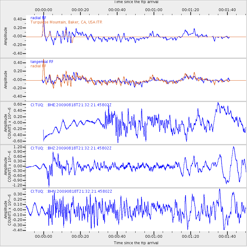
TUQ Turquiose Mountain, Baker, CA, USA - Earthquake Result Viewer
*The percent match for this event was below the threshold and hence no stack was calculated.
| Earthquake location: |
South Of Fiji Islands |
| Earthquake latitude/longitude: |
-26.1/-178.4 |
| Earthquake time(UTC): |
2009/08/18 (230) 21:20:47 GMT |
| Earthquake Depth: |
270 km |
| Earthquake Magnitude: |
5.5 MB, 6.3 MW, 6.3 MW |
| Earthquake Catalog/Contributor: |
WHDF/NEIC |
|
| Network: |
CI Caltech Regional Seismic Network |
| Station: |
TUQ Turquiose Mountain, Baker, CA, USA |
| Lat/Lon: |
35.44 N/115.92 W |
| Elevation: |
1350 m |
|
| Distance: |
85.0 deg |
| Az: |
46.626 deg |
| Baz: |
233.192 deg |
| Ray Param: |
$rayparam |
*The percent match for this event was below the threshold and hence was not used in the summary stack. |
|
| Radial Match: |
51.08128 % |
| Radial Bump: |
400 |
| Transverse Match: |
34.286556 % |
| Transverse Bump: |
400 |
| SOD ConfigId: |
2622 |
| Insert Time: |
2010-03-05 21:03:13.565 +0000 |
| GWidth: |
2.5 |
| Max Bumps: |
400 |
| Tol: |
0.001 |
|
Signal To Noise
| Channel | StoN | STA | LTA |
| CI:TUQ: :BHZ:20090818T21:32:21.45802Z | 9.837045 | 3.9859893E-7 | 4.052019E-8 |
| CI:TUQ: :BHN:20090818T21:32:21.45802Z | 1.8200378 | 1.1148914E-7 | 6.12565E-8 |
| CI:TUQ: :BHE:20090818T21:32:21.45802Z | 1.22794 | 2.1591451E-7 | 1.7583474E-7 |
| Arrivals |
| Ps | |
| PpPs | |
| PsPs/PpSs | |


