You are here: Home > Network List > AV - Alaska Volcano Observatory Stations List
> Station SPCR Ckakachatna River, Mount Spurr, Alaska > Earthquake Result Viewer
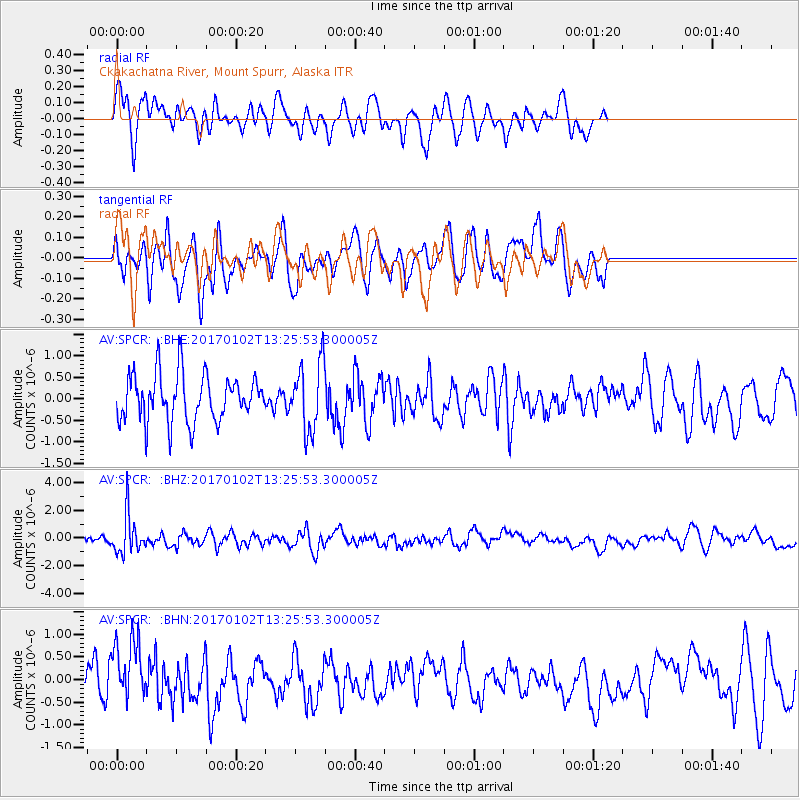
SPCR Ckakachatna River, Mount Spurr, Alaska - Earthquake Result Viewer
*The percent match for this event was below the threshold and hence no stack was calculated.
| Earthquake location: |
Northern Peru |
| Earthquake latitude/longitude: |
-4.9/-76.3 |
| Earthquake time(UTC): |
2017/01/02 (002) 13:13:48 GMT |
| Earthquake Depth: |
108 km |
| Earthquake Magnitude: |
5.9 Mwb |
| Earthquake Catalog/Contributor: |
NEIC PDE/us |
|
| Network: |
AV Alaska Volcano Observatory |
| Station: |
SPCR Ckakachatna River, Mount Spurr, Alaska |
| Lat/Lon: |
61.20 N/152.21 W |
| Elevation: |
984 m |
|
| Distance: |
87.5 deg |
| Az: |
331.964 deg |
| Baz: |
104.72 deg |
| Ray Param: |
$rayparam |
*The percent match for this event was below the threshold and hence was not used in the summary stack. |
|
| Radial Match: |
69.991844 % |
| Radial Bump: |
400 |
| Transverse Match: |
60.835194 % |
| Transverse Bump: |
400 |
| SOD ConfigId: |
11737051 |
| Insert Time: |
2019-04-26 11:59:21.750 +0000 |
| GWidth: |
2.5 |
| Max Bumps: |
400 |
| Tol: |
0.001 |
|
Signal To Noise
| Channel | StoN | STA | LTA |
| AV:SPCR: :BHZ:20170102T13:25:53.300005Z | 2.7296832 | 1.4066912E-6 | 5.1533135E-7 |
| AV:SPCR: :BHN:20170102T13:25:53.300005Z | 1.6076676 | 7.235253E-7 | 4.5004663E-7 |
| AV:SPCR: :BHE:20170102T13:25:53.300005Z | 1.4307775 | 7.7696495E-7 | 5.4303683E-7 |
| Arrivals |
| Ps | |
| PpPs | |
| PsPs/PpSs | |


