You are here: Home > Network List > CI - Caltech Regional Seismic Network Stations List
> Station TUQ Turquiose Mountain, Baker, CA, USA > Earthquake Result Viewer
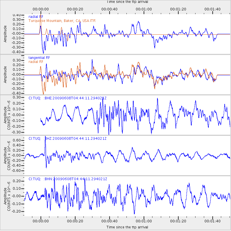
TUQ Turquiose Mountain, Baker, CA, USA - Earthquake Result Viewer
*The percent match for this event was below the threshold and hence no stack was calculated.
| Earthquake location: |
South Of Fiji Islands |
| Earthquake latitude/longitude: |
-22.2/-179.6 |
| Earthquake time(UTC): |
2009/06/08 (159) 04:33:19 GMT |
| Earthquake Depth: |
612 km |
| Earthquake Magnitude: |
5.5 MW, 5.2 MB |
| Earthquake Catalog/Contributor: |
WHDF/NEIC |
|
| Network: |
CI Caltech Regional Seismic Network |
| Station: |
TUQ Turquiose Mountain, Baker, CA, USA |
| Lat/Lon: |
35.44 N/115.92 W |
| Elevation: |
1350 m |
|
| Distance: |
83.2 deg |
| Az: |
47.491 deg |
| Baz: |
236.763 deg |
| Ray Param: |
$rayparam |
*The percent match for this event was below the threshold and hence was not used in the summary stack. |
|
| Radial Match: |
63.97513 % |
| Radial Bump: |
400 |
| Transverse Match: |
56.277954 % |
| Transverse Bump: |
400 |
| SOD ConfigId: |
2648 |
| Insert Time: |
2010-03-05 21:04:08.639 +0000 |
| GWidth: |
2.5 |
| Max Bumps: |
400 |
| Tol: |
0.001 |
|
Signal To Noise
| Channel | StoN | STA | LTA |
| CI:TUQ: :BHZ:20090608T04:44:11.294021Z | 3.4065962 | 2.4056982E-7 | 7.0618825E-8 |
| CI:TUQ: :BHN:20090608T04:44:11.294021Z | 0.9562479 | 5.193279E-8 | 5.4308916E-8 |
| CI:TUQ: :BHE:20090608T04:44:11.294021Z | 1.3787783 | 1.2945955E-7 | 9.389439E-8 |
| Arrivals |
| Ps | |
| PpPs | |
| PsPs/PpSs | |


