You are here: Home > Network List > CI - Caltech Regional Seismic Network Stations List
> Station SMM Simmler, CA, USA > Earthquake Result Viewer
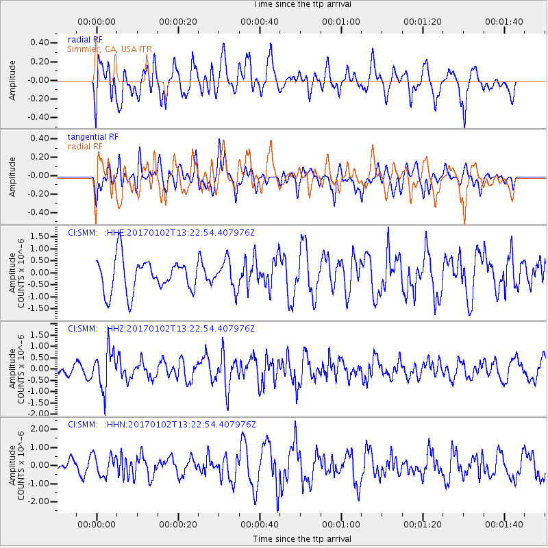
SMM Simmler, CA, USA - Earthquake Result Viewer
*The percent match for this event was below the threshold and hence no stack was calculated.
| Earthquake location: |
Northern Peru |
| Earthquake latitude/longitude: |
-4.9/-76.3 |
| Earthquake time(UTC): |
2017/01/02 (002) 13:13:48 GMT |
| Earthquake Depth: |
108 km |
| Earthquake Magnitude: |
5.9 Mwb |
| Earthquake Catalog/Contributor: |
NEIC PDE/us |
|
| Network: |
CI Caltech Regional Seismic Network |
| Station: |
SMM Simmler, CA, USA |
| Lat/Lon: |
35.31 N/120.00 W |
| Elevation: |
599 m |
|
| Distance: |
57.3 deg |
| Az: |
317.841 deg |
| Baz: |
125.138 deg |
| Ray Param: |
$rayparam |
*The percent match for this event was below the threshold and hence was not used in the summary stack. |
|
| Radial Match: |
64.92203 % |
| Radial Bump: |
400 |
| Transverse Match: |
45.937416 % |
| Transverse Bump: |
400 |
| SOD ConfigId: |
11737051 |
| Insert Time: |
2019-04-26 12:00:45.111 +0000 |
| GWidth: |
2.5 |
| Max Bumps: |
400 |
| Tol: |
0.001 |
|
Signal To Noise
| Channel | StoN | STA | LTA |
| CI:SMM: :HHZ:20170102T13:22:54.407976Z | 2.5468092 | 8.733427E-7 | 3.429164E-7 |
| CI:SMM: :HHN:20170102T13:22:54.407976Z | 1.2059344 | 5.668579E-7 | 4.7005702E-7 |
| CI:SMM: :HHE:20170102T13:22:54.407976Z | 0.88437223 | 6.14473E-7 | 6.9481257E-7 |
| Arrivals |
| Ps | |
| PpPs | |
| PsPs/PpSs | |


