You are here: Home > Network List > CI - Caltech Regional Seismic Network Stations List
> Station SWS Sam W. Stewart, Westmorland, CA, USA > Earthquake Result Viewer
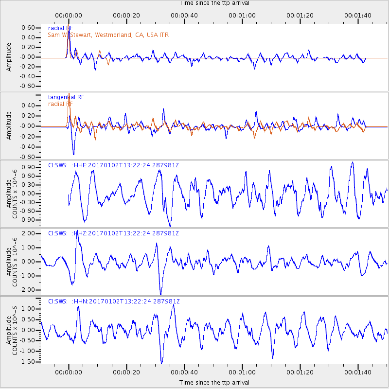
SWS Sam W. Stewart, Westmorland, CA, USA - Earthquake Result Viewer
*The percent match for this event was below the threshold and hence no stack was calculated.
| Earthquake location: |
Northern Peru |
| Earthquake latitude/longitude: |
-4.9/-76.3 |
| Earthquake time(UTC): |
2017/01/02 (002) 13:13:48 GMT |
| Earthquake Depth: |
108 km |
| Earthquake Magnitude: |
5.9 Mwb |
| Earthquake Catalog/Contributor: |
NEIC PDE/us |
|
| Network: |
CI Caltech Regional Seismic Network |
| Station: |
SWS Sam W. Stewart, Westmorland, CA, USA |
| Lat/Lon: |
32.94 N/115.80 W |
| Elevation: |
140 m |
|
| Distance: |
53.0 deg |
| Az: |
318.036 deg |
| Baz: |
127.597 deg |
| Ray Param: |
$rayparam |
*The percent match for this event was below the threshold and hence was not used in the summary stack. |
|
| Radial Match: |
73.646675 % |
| Radial Bump: |
400 |
| Transverse Match: |
76.812645 % |
| Transverse Bump: |
400 |
| SOD ConfigId: |
11737051 |
| Insert Time: |
2019-04-26 12:00:47.852 +0000 |
| GWidth: |
2.5 |
| Max Bumps: |
400 |
| Tol: |
0.001 |
|
Signal To Noise
| Channel | StoN | STA | LTA |
| CI:SWS: :HHZ:20170102T13:22:24.287981Z | 6.308697 | 1.2152775E-6 | 1.9263526E-7 |
| CI:SWS: :HHN:20170102T13:22:24.287981Z | 2.421061 | 5.0762907E-7 | 2.0967214E-7 |
| CI:SWS: :HHE:20170102T13:22:24.287981Z | 1.4937004 | 5.929208E-7 | 3.969476E-7 |
| Arrivals |
| Ps | |
| PpPs | |
| PsPs/PpSs | |


