You are here: Home > Network List > CN - Canadian National Seismograph Network Stations List
> Station INK INUVIK, NT > Earthquake Result Viewer
INK INUVIK, NT - Earthquake Result Viewer
*The percent match for this event was below the threshold and hence no stack was calculated.
| Earthquake location: |
Northern Peru |
| Earthquake latitude/longitude: |
-4.9/-76.3 |
| Earthquake time(UTC): |
2017/01/02 (002) 13:13:48 GMT |
| Earthquake Depth: |
108 km |
| Earthquake Magnitude: |
5.9 Mwb |
| Earthquake Catalog/Contributor: |
NEIC PDE/us |
|
| Network: |
CN Canadian National Seismograph Network |
| Station: |
INK INUVIK, NT |
| Lat/Lon: |
68.31 N/133.53 W |
| Elevation: |
44 m |
|
| Distance: |
83.0 deg |
| Az: |
341.65 deg |
| Baz: |
122.464 deg |
| Ray Param: |
$rayparam |
*The percent match for this event was below the threshold and hence was not used in the summary stack. |
|
| Radial Match: |
68.68794 % |
| Radial Bump: |
400 |
| Transverse Match: |
67.07933 % |
| Transverse Bump: |
400 |
| SOD ConfigId: |
11737051 |
| Insert Time: |
2019-04-26 12:01:22.147 +0000 |
| GWidth: |
2.5 |
| Max Bumps: |
400 |
| Tol: |
0.001 |
|
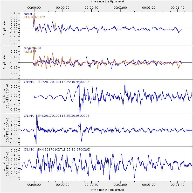
Signal To Noise
| Channel | StoN | STA | LTA |
| CN:INK: :BHZ:20170102T13:25:30.950029Z | 12.071509 | 1.561057E-6 | 1.2931746E-7 |
| CN:INK: :BHN:20170102T13:25:30.950029Z | 1.9100752 | 2.549713E-7 | 1.3348757E-7 |
| CN:INK: :BHE:20170102T13:25:30.950029Z | 4.016885 | 5.5537066E-7 | 1.3825904E-7 |
| Arrivals |
| Ps | |
| PpPs | |
| PsPs/PpSs | |


