You are here: Home > Network List > CI - Caltech Regional Seismic Network Stations List
> Station TUQ Turquiose Mountain, Baker, CA, USA > Earthquake Result Viewer
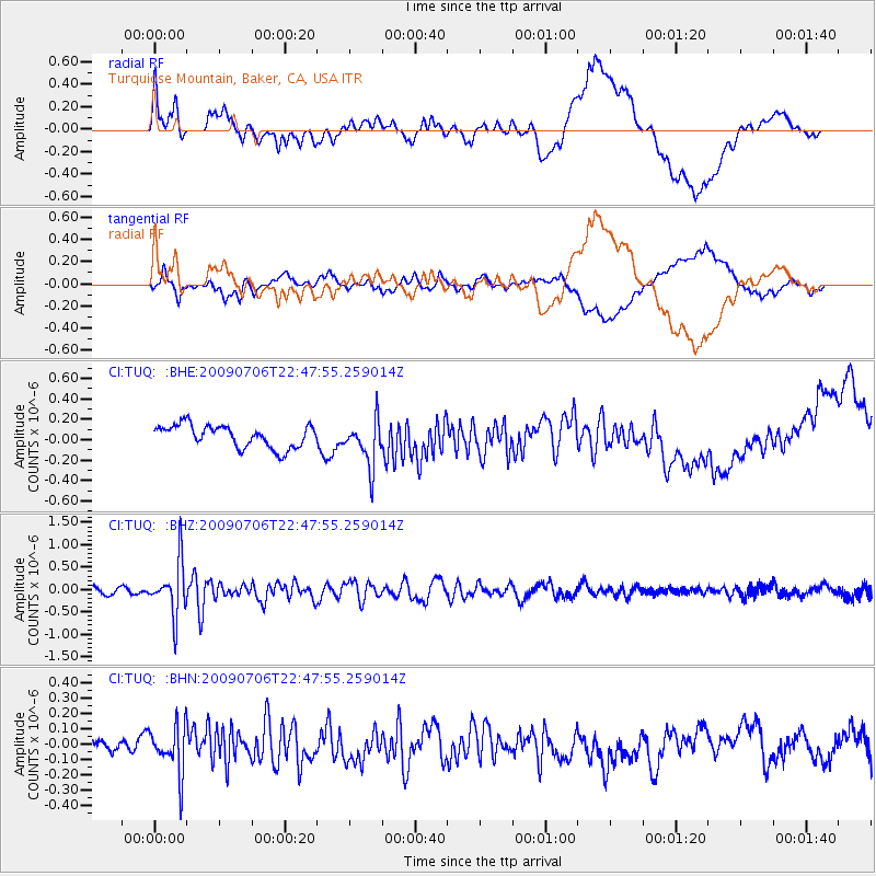
TUQ Turquiose Mountain, Baker, CA, USA - Earthquake Result Viewer
*The percent match for this event was below the threshold and hence no stack was calculated.
| Earthquake location: |
Southeast Of Ryukyu Islands |
| Earthquake latitude/longitude: |
24.9/128.0 |
| Earthquake time(UTC): |
2009/07/06 (187) 22:35:05 GMT |
| Earthquake Depth: |
10 km |
| Earthquake Magnitude: |
6.1 MB, 5.3 MS, 5.7 MW, 5.7 MW |
| Earthquake Catalog/Contributor: |
WHDF/NEIC |
|
| Network: |
CI Caltech Regional Seismic Network |
| Station: |
TUQ Turquiose Mountain, Baker, CA, USA |
| Lat/Lon: |
35.44 N/115.92 W |
| Elevation: |
1350 m |
|
| Distance: |
94.8 deg |
| Az: |
47.414 deg |
| Baz: |
305.02 deg |
| Ray Param: |
$rayparam |
*The percent match for this event was below the threshold and hence was not used in the summary stack. |
|
| Radial Match: |
39.684166 % |
| Radial Bump: |
400 |
| Transverse Match: |
34.02884 % |
| Transverse Bump: |
400 |
| SOD ConfigId: |
2648 |
| Insert Time: |
2010-03-05 21:04:46.623 +0000 |
| GWidth: |
2.5 |
| Max Bumps: |
400 |
| Tol: |
0.001 |
|
Signal To Noise
| Channel | StoN | STA | LTA |
| CI:TUQ: :BHZ:20090706T22:47:55.259014Z | 7.585867 | 5.9108527E-7 | 7.791928E-8 |
| CI:TUQ: :BHN:20090706T22:47:55.259014Z | 2.4457462 | 1.5521933E-7 | 6.3465016E-8 |
| CI:TUQ: :BHE:20090706T22:47:55.259014Z | 2.0787659 | 2.2865757E-7 | 1.09996776E-7 |
| Arrivals |
| Ps | |
| PpPs | |
| PsPs/PpSs | |


