You are here: Home > Network List > CI - Caltech Regional Seismic Network Stations List
> Station TUQ Turquiose Mountain, Baker, CA, USA > Earthquake Result Viewer
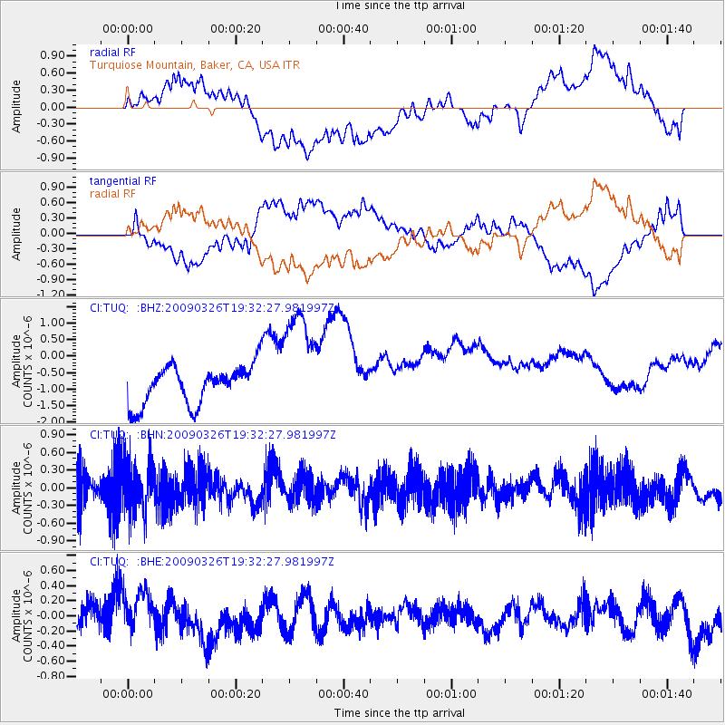
TUQ Turquiose Mountain, Baker, CA, USA - Earthquake Result Viewer
*The percent match for this event was below the threshold and hence no stack was calculated.
| Earthquake location: |
Northwest Of Ryukyu Islands |
| Earthquake latitude/longitude: |
27.4/126.7 |
| Earthquake time(UTC): |
2009/03/26 (085) 19:19:59 GMT |
| Earthquake Depth: |
160 km |
| Earthquake Magnitude: |
5.6 MB, 5.9 MW, 5.9 MW |
| Earthquake Catalog/Contributor: |
WHDF/NEIC |
|
| Network: |
CI Caltech Regional Seismic Network |
| Station: |
TUQ Turquiose Mountain, Baker, CA, USA |
| Lat/Lon: |
35.44 N/115.92 W |
| Elevation: |
1350 m |
|
| Distance: |
94.0 deg |
| Az: |
46.628 deg |
| Baz: |
307.691 deg |
| Ray Param: |
$rayparam |
*The percent match for this event was below the threshold and hence was not used in the summary stack. |
|
| Radial Match: |
32.306206 % |
| Radial Bump: |
400 |
| Transverse Match: |
38.412407 % |
| Transverse Bump: |
400 |
| SOD ConfigId: |
2658 |
| Insert Time: |
2010-03-05 21:04:48.858 +0000 |
| GWidth: |
2.5 |
| Max Bumps: |
400 |
| Tol: |
0.001 |
|
Signal To Noise
| Channel | StoN | STA | LTA |
| CI:TUQ: :BHN:20090326T19:32:27.981997Z | 1.3055904 | 4.3653958E-7 | 3.3436183E-7 |
| CI:TUQ: :BHE:20090326T19:32:27.981997Z | 1.5956597 | 2.8775258E-7 | 1.8033454E-7 |
| CI:TUQ: :BHZ:20090326T19:32:27.981997Z | 2.9519403 | 1.7398196E-6 | 5.893817E-7 |
| Arrivals |
| Ps | |
| PpPs | |
| PsPs/PpSs | |


