You are here: Home > Network List > CI - Caltech Regional Seismic Network Stations List
> Station TUQ Turquiose Mountain, Baker, CA, USA > Earthquake Result Viewer
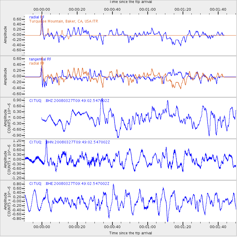
TUQ Turquiose Mountain, Baker, CA, USA - Earthquake Result Viewer
*The percent match for this event was below the threshold and hence no stack was calculated.
| Earthquake location: |
North Of Honduras |
| Earthquake latitude/longitude: |
17.2/-84.8 |
| Earthquake time(UTC): |
2008/03/27 (087) 09:42:57 GMT |
| Earthquake Depth: |
10 km |
| Earthquake Magnitude: |
5.6 MW, 5.1 MS, 5.4 MB, 5.6 MW |
| Earthquake Catalog/Contributor: |
WHDF/NEIC |
|
| Network: |
CI Caltech Regional Seismic Network |
| Station: |
TUQ Turquiose Mountain, Baker, CA, USA |
| Lat/Lon: |
35.44 N/115.92 W |
| Elevation: |
1350 m |
|
| Distance: |
33.1 deg |
| Az: |
309.387 deg |
| Baz: |
115.222 deg |
| Ray Param: |
$rayparam |
*The percent match for this event was below the threshold and hence was not used in the summary stack. |
|
| Radial Match: |
51.280025 % |
| Radial Bump: |
400 |
| Transverse Match: |
56.220184 % |
| Transverse Bump: |
400 |
| SOD ConfigId: |
2504 |
| Insert Time: |
2010-03-05 21:05:07.547 +0000 |
| GWidth: |
2.5 |
| Max Bumps: |
400 |
| Tol: |
0.001 |
|
Signal To Noise
| Channel | StoN | STA | LTA |
| CI:TUQ: :BHN:20080327T09:49:02.547002Z | 4.2668667 | 4.3425496E-7 | 1.0177373E-7 |
| CI:TUQ: :BHE:20080327T09:49:02.547002Z | 1.3378654 | 2.7609357E-7 | 2.0636874E-7 |
| CI:TUQ: :BHZ:20080327T09:49:02.547002Z | 1.8939197 | 4.953412E-7 | 2.6154288E-7 |
| Arrivals |
| Ps | |
| PpPs | |
| PsPs/PpSs | |


