You are here: Home > Network List > LD - Lamont-Doherty Cooperative Seismographic Network Stations List
> Station WVNY West Valley, New York > Earthquake Result Viewer
WVNY West Valley, New York - Earthquake Result Viewer
| Earthquake location: |
Northern Peru |
| Earthquake latitude/longitude: |
-4.9/-76.3 |
| Earthquake time(UTC): |
2017/01/02 (002) 13:13:48 GMT |
| Earthquake Depth: |
108 km |
| Earthquake Magnitude: |
5.9 Mwb |
| Earthquake Catalog/Contributor: |
NEIC PDE/us |
|
| Network: |
LD Lamont-Doherty Cooperative Seismographic Network |
| Station: |
WVNY West Valley, New York |
| Lat/Lon: |
42.41 N/78.60 W |
| Elevation: |
490 m |
|
| Distance: |
47.1 deg |
| Az: |
357.712 deg |
| Baz: |
176.921 deg |
| Ray Param: |
0.06983105 |
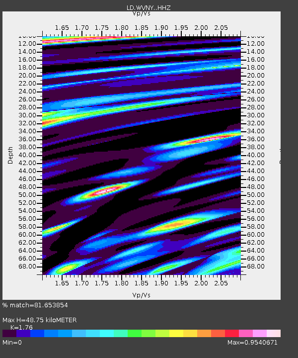
| Estimated Moho Depth: |
48.75 km |
| Estimated Crust Vp/Vs: |
1.76 |
| Assumed Crust Vp: |
6.419 km/s |
| Estimated Crust Vs: |
3.647 km/s |
| Estimated Crust Poisson's Ratio: |
0.26 |
|
| Radial Match: |
81.653854 % |
| Radial Bump: |
400 |
| Transverse Match: |
69.38674 % |
| Transverse Bump: |
400 |
| SOD ConfigId: |
11737051 |
| Insert Time: |
2019-04-26 12:03:33.632 +0000 |
| GWidth: |
2.5 |
| Max Bumps: |
400 |
| Tol: |
0.001 |
|

Signal To Noise
| Channel | StoN | STA | LTA |
| LD:WVNY: :HHZ:20170102T13:21:39.670Z | 10.592983 | 3.313228E-6 | 3.1277574E-7 |
| LD:WVNY: :HHN:20170102T13:21:39.670Z | 5.447181 | 1.5298718E-6 | 2.808557E-7 |
| LD:WVNY: :HHE:20170102T13:21:39.670Z | 1.4502455 | 3.4933217E-7 | 2.4087797E-7 |
| Arrivals |
| Ps | 6.1 SECOND |
| PpPs | 20 SECOND |
| PsPs/PpSs | 26 SECOND |


