You are here: Home > Network List > CI - Caltech Regional Seismic Network Stations List
> Station TUQ Turquiose Mountain, Baker, CA, USA > Earthquake Result Viewer
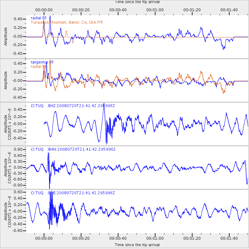
TUQ Turquiose Mountain, Baker, CA, USA - Earthquake Result Viewer
*The percent match for this event was below the threshold and hence no stack was calculated.
| Earthquake location: |
Bonin Islands, Japan Region |
| Earthquake latitude/longitude: |
27.8/139.6 |
| Earthquake time(UTC): |
2008/07/20 (202) 21:30:29 GMT |
| Earthquake Depth: |
481 km |
| Earthquake Magnitude: |
5.8 MW, 5.1 MB, 5.8 MW |
| Earthquake Catalog/Contributor: |
WHDF/NEIC |
|
| Network: |
CI Caltech Regional Seismic Network |
| Station: |
TUQ Turquiose Mountain, Baker, CA, USA |
| Lat/Lon: |
35.44 N/115.92 W |
| Elevation: |
1350 m |
|
| Distance: |
85.0 deg |
| Az: |
52.535 deg |
| Baz: |
300.541 deg |
| Ray Param: |
$rayparam |
*The percent match for this event was below the threshold and hence was not used in the summary stack. |
|
| Radial Match: |
70.63962 % |
| Radial Bump: |
400 |
| Transverse Match: |
57.245033 % |
| Transverse Bump: |
400 |
| SOD ConfigId: |
2504 |
| Insert Time: |
2010-03-05 21:05:37.212 +0000 |
| GWidth: |
2.5 |
| Max Bumps: |
400 |
| Tol: |
0.001 |
|
Signal To Noise
| Channel | StoN | STA | LTA |
| CI:TUQ: :BHN:20080720T21:41:42.295996Z | 2.509279 | 3.421255E-7 | 1.3634416E-7 |
| CI:TUQ: :BHE:20080720T21:41:42.295996Z | 1.8069513 | 2.4286703E-7 | 1.3440707E-7 |
| CI:TUQ: :BHZ:20080720T21:41:42.295996Z | 2.115372 | 3.3689818E-7 | 1.5926192E-7 |
| Arrivals |
| Ps | |
| PpPs | |
| PsPs/PpSs | |


