You are here: Home > Network List > N4 - Central and EAstern US Network Stations List
> Station Q56A Snyder Ridge, Maysville, WV, USA > Earthquake Result Viewer
Q56A Snyder Ridge, Maysville, WV, USA - Earthquake Result Viewer
| Earthquake location: |
Northern Peru |
| Earthquake latitude/longitude: |
-4.9/-76.3 |
| Earthquake time(UTC): |
2017/01/02 (002) 13:13:48 GMT |
| Earthquake Depth: |
108 km |
| Earthquake Magnitude: |
5.9 Mwb |
| Earthquake Catalog/Contributor: |
NEIC PDE/us |
|
| Network: |
N4 Central and EAstern US Network |
| Station: |
Q56A Snyder Ridge, Maysville, WV, USA |
| Lat/Lon: |
39.04 N/79.19 W |
| Elevation: |
430 m |
|
| Distance: |
43.8 deg |
| Az: |
356.796 deg |
| Baz: |
175.9 deg |
| Ray Param: |
0.07195007 |
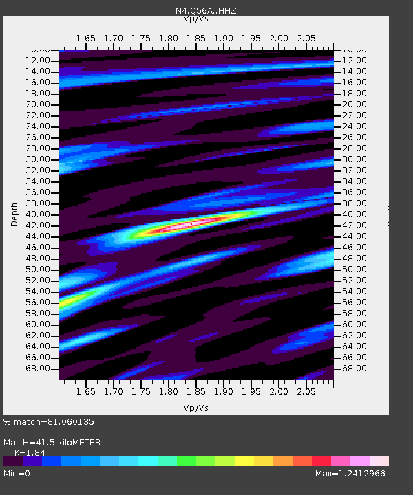
| Estimated Moho Depth: |
41.5 km |
| Estimated Crust Vp/Vs: |
1.84 |
| Assumed Crust Vp: |
6.159 km/s |
| Estimated Crust Vs: |
3.347 km/s |
| Estimated Crust Poisson's Ratio: |
0.29 |
|
| Radial Match: |
81.060135 % |
| Radial Bump: |
397 |
| Transverse Match: |
66.080215 % |
| Transverse Bump: |
400 |
| SOD ConfigId: |
11737051 |
| Insert Time: |
2019-04-26 12:05:00.462 +0000 |
| GWidth: |
2.5 |
| Max Bumps: |
400 |
| Tol: |
0.001 |
|

Signal To Noise
| Channel | StoN | STA | LTA |
| N4:Q56A: :HHZ:20170102T13:21:13.469988Z | 9.855793 | 2.065298E-6 | 2.0955169E-7 |
| N4:Q56A: :HHN:20170102T13:21:13.469988Z | 6.208616 | 1.2730712E-6 | 2.0504912E-7 |
| N4:Q56A: :HHE:20170102T13:21:13.469988Z | 2.6769 | 4.369039E-7 | 1.6321265E-7 |
| Arrivals |
| Ps | 6.0 SECOND |
| PpPs | 18 SECOND |
| PsPs/PpSs | 24 SECOND |


