You are here: Home > Network List > N4 - Central and EAstern US Network Stations List
> Station V51A Loudon, TN, USA > Earthquake Result Viewer
V51A Loudon, TN, USA - Earthquake Result Viewer
| Earthquake location: |
Northern Peru |
| Earthquake latitude/longitude: |
-4.9/-76.3 |
| Earthquake time(UTC): |
2017/01/02 (002) 13:13:48 GMT |
| Earthquake Depth: |
108 km |
| Earthquake Magnitude: |
5.9 Mwb |
| Earthquake Catalog/Contributor: |
NEIC PDE/us |
|
| Network: |
N4 Central and EAstern US Network |
| Station: |
V51A Loudon, TN, USA |
| Lat/Lon: |
35.80 N/84.35 W |
| Elevation: |
243 m |
|
| Distance: |
41.2 deg |
| Az: |
350.091 deg |
| Baz: |
167.823 deg |
| Ray Param: |
0.0735716 |
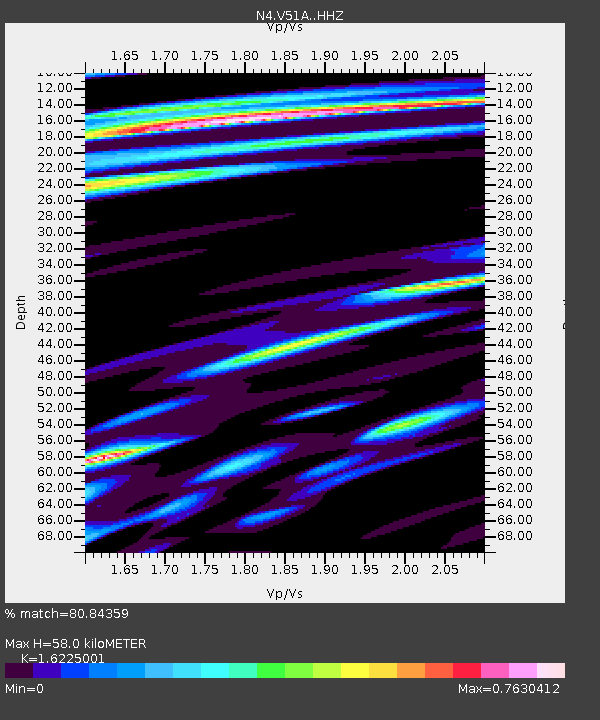
| Estimated Moho Depth: |
58.0 km |
| Estimated Crust Vp/Vs: |
1.62 |
| Assumed Crust Vp: |
6.35 km/s |
| Estimated Crust Vs: |
3.914 km/s |
| Estimated Crust Poisson's Ratio: |
0.19 |
|
| Radial Match: |
80.84359 % |
| Radial Bump: |
400 |
| Transverse Match: |
52.16133 % |
| Transverse Bump: |
400 |
| SOD ConfigId: |
11737051 |
| Insert Time: |
2019-04-26 12:05:28.958 +0000 |
| GWidth: |
2.5 |
| Max Bumps: |
400 |
| Tol: |
0.001 |
|

Signal To Noise
| Channel | StoN | STA | LTA |
| N4:V51A: :HHZ:20170102T13:20:52.300005Z | 14.553258 | 2.1183216E-6 | 1.4555653E-7 |
| N4:V51A: :HHN:20170102T13:20:52.300005Z | 6.030986 | 1.1802384E-6 | 1.9569578E-7 |
| N4:V51A: :HHE:20170102T13:20:52.300005Z | 1.9786696 | 3.7805518E-7 | 1.9106533E-7 |
| Arrivals |
| Ps | 6.1 SECOND |
| PpPs | 22 SECOND |
| PsPs/PpSs | 28 SECOND |


