You are here: Home > Network List > CI - Caltech Regional Seismic Network Stations List
> Station EDW2 EDW2, Mojave, CA, USA > Earthquake Result Viewer
EDW2 EDW2, Mojave, CA, USA - Earthquake Result Viewer
| Earthquake location: |
Hokkaido, Japan Region |
| Earthquake latitude/longitude: |
43.0/145.1 |
| Earthquake time(UTC): |
2004/11/28 (333) 18:32:14 GMT |
| Earthquake Depth: |
39 km |
| Earthquake Magnitude: |
6.4 MB, 6.7 MS, 7.0 MW, 7.0 MW |
| Earthquake Catalog/Contributor: |
WHDF/NEIC |
|
| Network: |
CI Caltech Regional Seismic Network |
| Station: |
EDW2 EDW2, Mojave, CA, USA |
| Lat/Lon: |
34.88 N/117.99 W |
| Elevation: |
772 m |
|
| Distance: |
71.7 deg |
| Az: |
59.301 deg |
| Baz: |
309.895 deg |
| Ray Param: |
0.054111086 |
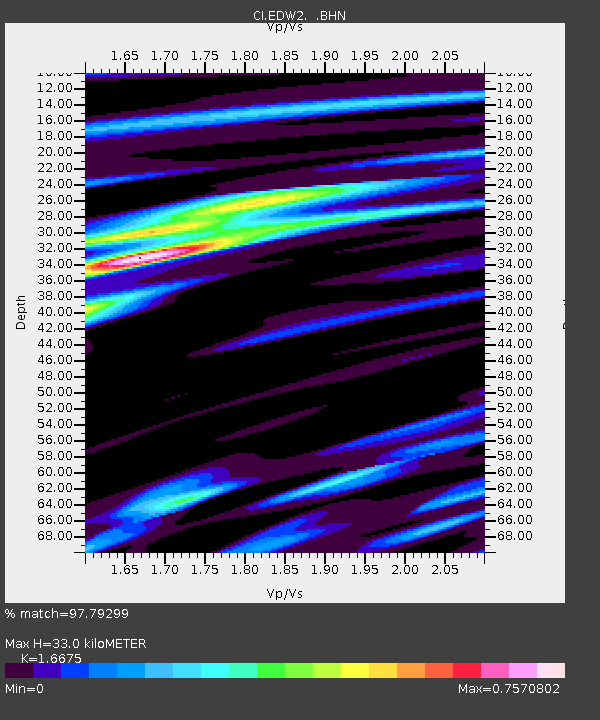
| Estimated Moho Depth: |
33.0 km |
| Estimated Crust Vp/Vs: |
1.67 |
| Assumed Crust Vp: |
6.276 km/s |
| Estimated Crust Vs: |
3.764 km/s |
| Estimated Crust Poisson's Ratio: |
0.22 |
|
| Radial Match: |
97.79299 % |
| Radial Bump: |
292 |
| Transverse Match: |
91.33268 % |
| Transverse Bump: |
400 |
| SOD ConfigId: |
2459 |
| Insert Time: |
2010-03-05 21:05:51.293 +0000 |
| GWidth: |
2.5 |
| Max Bumps: |
400 |
| Tol: |
0.001 |
|
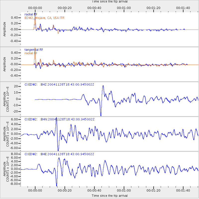
Signal To Noise
| Channel | StoN | STA | LTA |
| CI:EDW2: :BHN:20041128T18:43:00.945002Z | 3.1911366 | 9.132294E-7 | 2.8617686E-7 |
| CI:EDW2: :BHE:20041128T18:43:00.945002Z | 6.0083547 | 1.525835E-6 | 2.539522E-7 |
| CI:EDW2: :BHZ:20041128T18:43:00.945002Z | 16.955631 | 3.8665053E-6 | 2.2803664E-7 |
| Arrivals |
| Ps | 3.6 SECOND |
| PpPs | 14 SECOND |
| PsPs/PpSs | 17 SECOND |


