You are here: Home > Network List > TA - USArray Transportable Network (new EarthScope stations) Stations List
> Station D25K Kavik River, AK, USA > Earthquake Result Viewer
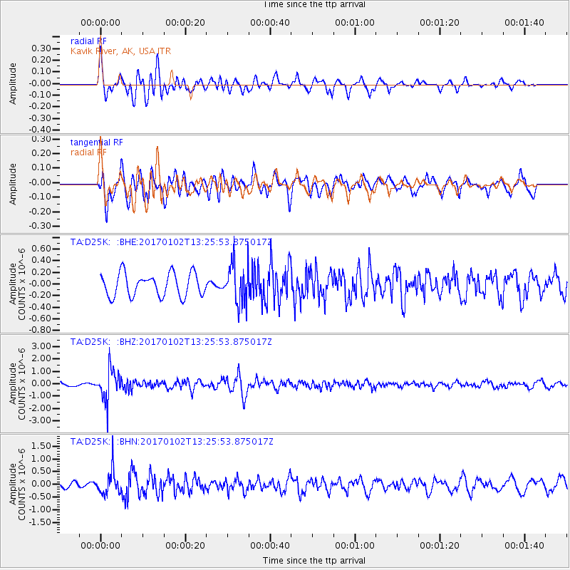
D25K Kavik River, AK, USA - Earthquake Result Viewer
*The percent match for this event was below the threshold and hence no stack was calculated.
| Earthquake location: |
Northern Peru |
| Earthquake latitude/longitude: |
-4.9/-76.3 |
| Earthquake time(UTC): |
2017/01/02 (002) 13:13:48 GMT |
| Earthquake Depth: |
108 km |
| Earthquake Magnitude: |
5.9 Mwb |
| Earthquake Catalog/Contributor: |
NEIC PDE/us |
|
| Network: |
TA USArray Transportable Network (new EarthScope stations) |
| Station: |
D25K Kavik River, AK, USA |
| Lat/Lon: |
69.32 N/146.38 W |
| Elevation: |
770 m |
|
| Distance: |
87.6 deg |
| Az: |
340.48 deg |
| Baz: |
110.391 deg |
| Ray Param: |
$rayparam |
*The percent match for this event was below the threshold and hence was not used in the summary stack. |
|
| Radial Match: |
71.96634 % |
| Radial Bump: |
400 |
| Transverse Match: |
74.677956 % |
| Transverse Bump: |
400 |
| SOD ConfigId: |
11737051 |
| Insert Time: |
2019-04-26 12:08:16.941 +0000 |
| GWidth: |
2.5 |
| Max Bumps: |
400 |
| Tol: |
0.001 |
|
Signal To Noise
| Channel | StoN | STA | LTA |
| TA:D25K: :BHZ:20170102T13:25:53.875017Z | 10.291671 | 1.27639E-6 | 1.2402165E-7 |
| TA:D25K: :BHN:20170102T13:25:53.875017Z | 3.806346 | 4.8637014E-7 | 1.2777875E-7 |
| TA:D25K: :BHE:20170102T13:25:53.875017Z | 1.7721082 | 3.5006525E-7 | 1.975417E-7 |
| Arrivals |
| Ps | |
| PpPs | |
| PsPs/PpSs | |


