You are here: Home > Network List > CI - Caltech Regional Seismic Network Stations List
> Station EDW2 EDW2, Mojave, CA, USA > Earthquake Result Viewer
EDW2 EDW2, Mojave, CA, USA - Earthquake Result Viewer
| Earthquake location: |
Kermadec Islands Region |
| Earthquake latitude/longitude: |
-27.4/-176.3 |
| Earthquake time(UTC): |
2009/02/18 (049) 21:53:45 GMT |
| Earthquake Depth: |
25 km |
| Earthquake Magnitude: |
6.8 MB, 7.2 MS, 6.9 MW, 6.9 MW |
| Earthquake Catalog/Contributor: |
WHDF/NEIC |
|
| Network: |
CI Caltech Regional Seismic Network |
| Station: |
EDW2 EDW2, Mojave, CA, USA |
| Lat/Lon: |
34.88 N/117.99 W |
| Elevation: |
772 m |
|
| Distance: |
82.9 deg |
| Az: |
44.837 deg |
| Baz: |
229.67 deg |
| Ray Param: |
0.046506535 |
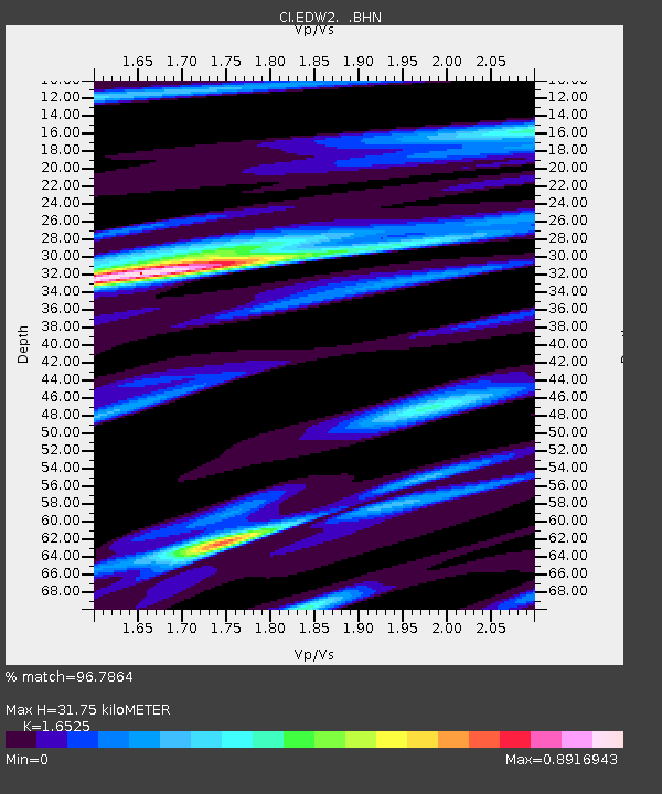
| Estimated Moho Depth: |
31.75 km |
| Estimated Crust Vp/Vs: |
1.65 |
| Assumed Crust Vp: |
6.276 km/s |
| Estimated Crust Vs: |
3.798 km/s |
| Estimated Crust Poisson's Ratio: |
0.21 |
|
| Radial Match: |
96.7864 % |
| Radial Bump: |
293 |
| Transverse Match: |
91.03962 % |
| Transverse Bump: |
323 |
| SOD ConfigId: |
2658 |
| Insert Time: |
2010-03-05 21:06:15.775 +0000 |
| GWidth: |
2.5 |
| Max Bumps: |
400 |
| Tol: |
0.001 |
|

Signal To Noise
| Channel | StoN | STA | LTA |
| CI:EDW2: :BHN:20090218T22:05:36.519009Z | 18.370838 | 3.4699283E-6 | 1.8888241E-7 |
| CI:EDW2: :BHE:20090218T22:05:36.519009Z | 5.7150974 | 8.4437227E-7 | 1.4774417E-7 |
| CI:EDW2: :BHZ:20090218T22:05:36.519009Z | 4.8587437 | 1.0482235E-6 | 2.1573962E-7 |
| Arrivals |
| Ps | 3.4 SECOND |
| PpPs | 13 SECOND |
| PsPs/PpSs | 16 SECOND |


