You are here: Home > Network List > CI - Caltech Regional Seismic Network Stations List
> Station EDW2 EDW2, Mojave, CA, USA > Earthquake Result Viewer
EDW2 EDW2, Mojave, CA, USA - Earthquake Result Viewer
| Earthquake location: |
Chile-Bolivia Border Region |
| Earthquake latitude/longitude: |
-22.3/-67.9 |
| Earthquake time(UTC): |
2005/11/17 (321) 19:26:56 GMT |
| Earthquake Depth: |
163 km |
| Earthquake Magnitude: |
6.0 MB, 6.9 MW, 6.8 MW |
| Earthquake Catalog/Contributor: |
WHDF/NEIC |
|
| Network: |
CI Caltech Regional Seismic Network |
| Station: |
EDW2 EDW2, Mojave, CA, USA |
| Lat/Lon: |
34.88 N/117.99 W |
| Elevation: |
772 m |
|
| Distance: |
74.1 deg |
| Az: |
319.024 deg |
| Baz: |
132.391 deg |
| Ray Param: |
0.052111864 |
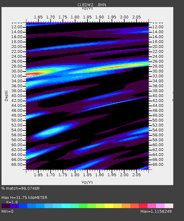
| Estimated Moho Depth: |
31.75 km |
| Estimated Crust Vp/Vs: |
1.60 |
| Assumed Crust Vp: |
6.276 km/s |
| Estimated Crust Vs: |
3.922 km/s |
| Estimated Crust Poisson's Ratio: |
0.18 |
|
| Radial Match: |
96.07469 % |
| Radial Bump: |
400 |
| Transverse Match: |
90.54517 % |
| Transverse Bump: |
400 |
| SOD ConfigId: |
2422 |
| Insert Time: |
2010-03-05 21:06:27.664 +0000 |
| GWidth: |
2.5 |
| Max Bumps: |
400 |
| Tol: |
0.001 |
|

Signal To Noise
| Channel | StoN | STA | LTA |
| CI:EDW2: :BHN:20051117T19:37:43.995002Z | 9.687796 | 1.2533422E-6 | 1.2937332E-7 |
| CI:EDW2: :BHE:20051117T19:37:43.995002Z | 9.83325 | 1.4415593E-6 | 1.466005E-7 |
| CI:EDW2: :BHZ:20051117T19:37:43.995002Z | 39.17871 | 5.575972E-6 | 1.4232147E-7 |
| Arrivals |
| Ps | 3.1 SECOND |
| PpPs | 13 SECOND |
| PsPs/PpSs | 16 SECOND |


