You are here: Home > Network List > TA - USArray Transportable Network (new EarthScope stations) Stations List
> Station R32K Eaglecrest, AK, USA > Earthquake Result Viewer
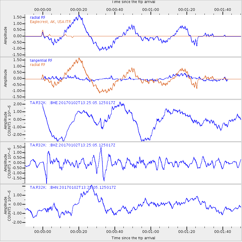
R32K Eaglecrest, AK, USA - Earthquake Result Viewer
*The percent match for this event was below the threshold and hence no stack was calculated.
| Earthquake location: |
Northern Peru |
| Earthquake latitude/longitude: |
-4.9/-76.3 |
| Earthquake time(UTC): |
2017/01/02 (002) 13:13:48 GMT |
| Earthquake Depth: |
108 km |
| Earthquake Magnitude: |
5.9 Mwb |
| Earthquake Catalog/Contributor: |
NEIC PDE/us |
|
| Network: |
TA USArray Transportable Network (new EarthScope stations) |
| Station: |
R32K Eaglecrest, AK, USA |
| Lat/Lon: |
58.27 N/134.52 W |
| Elevation: |
386 m |
|
| Distance: |
78.1 deg |
| Az: |
332.691 deg |
| Baz: |
120.101 deg |
| Ray Param: |
$rayparam |
*The percent match for this event was below the threshold and hence was not used in the summary stack. |
|
| Radial Match: |
29.417635 % |
| Radial Bump: |
400 |
| Transverse Match: |
27.515497 % |
| Transverse Bump: |
400 |
| SOD ConfigId: |
11737051 |
| Insert Time: |
2019-04-26 12:09:24.124 +0000 |
| GWidth: |
2.5 |
| Max Bumps: |
400 |
| Tol: |
0.001 |
|
Signal To Noise
| Channel | StoN | STA | LTA |
| TA:R32K: :BHZ:20170102T13:25:05.125017Z | 3.7949572 | 7.8040057E-7 | 2.0564147E-7 |
| TA:R32K: :BHN:20170102T13:25:05.125017Z | 1.3657976 | 1.2480589E-6 | 9.1379485E-7 |
| TA:R32K: :BHE:20170102T13:25:05.125017Z | 0.2840565 | 4.1386215E-7 | 1.4569711E-6 |
| Arrivals |
| Ps | |
| PpPs | |
| PsPs/PpSs | |


