You are here: Home > Network List > TX - Texas Seismological Network Stations List
> Station FW01 Dallas Executive Airport > Earthquake Result Viewer
FW01 Dallas Executive Airport - Earthquake Result Viewer
| Earthquake location: |
Northern Peru |
| Earthquake latitude/longitude: |
-4.9/-76.3 |
| Earthquake time(UTC): |
2017/01/02 (002) 13:13:48 GMT |
| Earthquake Depth: |
108 km |
| Earthquake Magnitude: |
5.9 Mwb |
| Earthquake Catalog/Contributor: |
NEIC PDE/us |
|
| Network: |
TX Texas Seismological Network |
| Station: |
FW01 Dallas Executive Airport |
| Lat/Lon: |
32.68 N/96.88 W |
| Elevation: |
203 m |
|
| Distance: |
42.2 deg |
| Az: |
333.842 deg |
| Baz: |
148.609 deg |
| Ray Param: |
0.07298267 |
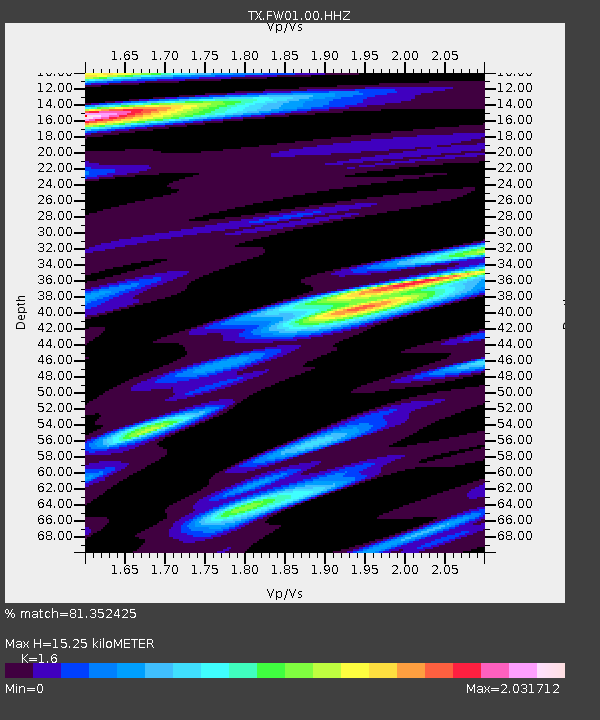
| Estimated Moho Depth: |
15.25 km |
| Estimated Crust Vp/Vs: |
1.60 |
| Assumed Crust Vp: |
6.38 km/s |
| Estimated Crust Vs: |
3.988 km/s |
| Estimated Crust Poisson's Ratio: |
0.18 |
|
| Radial Match: |
81.352425 % |
| Radial Bump: |
399 |
| Transverse Match: |
55.832767 % |
| Transverse Bump: |
400 |
| SOD ConfigId: |
11737051 |
| Insert Time: |
2019-04-26 12:09:51.480 +0000 |
| GWidth: |
2.5 |
| Max Bumps: |
400 |
| Tol: |
0.001 |
|

Signal To Noise
| Channel | StoN | STA | LTA |
| TX:FW01:00:HHZ:20170102T13:21:00.229998Z | 9.096344 | 2.4627432E-6 | 2.707399E-7 |
| TX:FW01:00:HH1:20170102T13:21:00.229998Z | 3.0010824 | 8.209968E-7 | 2.7356688E-7 |
| TX:FW01:00:HH2:20170102T13:21:00.229998Z | 2.411436 | 7.545117E-7 | 3.1288894E-7 |
| Arrivals |
| Ps | 1.5 SECOND |
| PpPs | 5.8 SECOND |
| PsPs/PpSs | 7.3 SECOND |


