You are here: Home > Network List > CI - Caltech Regional Seismic Network Stations List
> Station EDW2 EDW2, Mojave, CA, USA > Earthquake Result Viewer
EDW2 EDW2, Mojave, CA, USA - Earthquake Result Viewer
| Earthquake location: |
Solomon Islands |
| Earthquake latitude/longitude: |
-10.5/161.3 |
| Earthquake time(UTC): |
2008/06/03 (155) 16:20:50 GMT |
| Earthquake Depth: |
84 km |
| Earthquake Magnitude: |
6.2 MB, 6.2 MW, 6.2 MW |
| Earthquake Catalog/Contributor: |
WHDF/NEIC |
|
| Network: |
CI Caltech Regional Seismic Network |
| Station: |
EDW2 EDW2, Mojave, CA, USA |
| Lat/Lon: |
34.88 N/117.99 W |
| Elevation: |
772 m |
|
| Distance: |
88.5 deg |
| Az: |
54.263 deg |
| Baz: |
256.159 deg |
| Ray Param: |
0.04240944 |
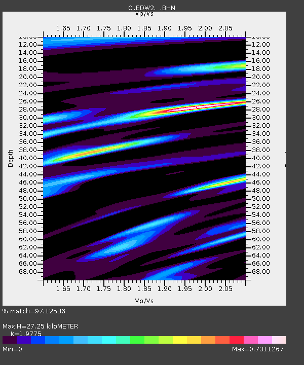
| Estimated Moho Depth: |
27.25 km |
| Estimated Crust Vp/Vs: |
1.98 |
| Assumed Crust Vp: |
6.276 km/s |
| Estimated Crust Vs: |
3.174 km/s |
| Estimated Crust Poisson's Ratio: |
0.33 |
|
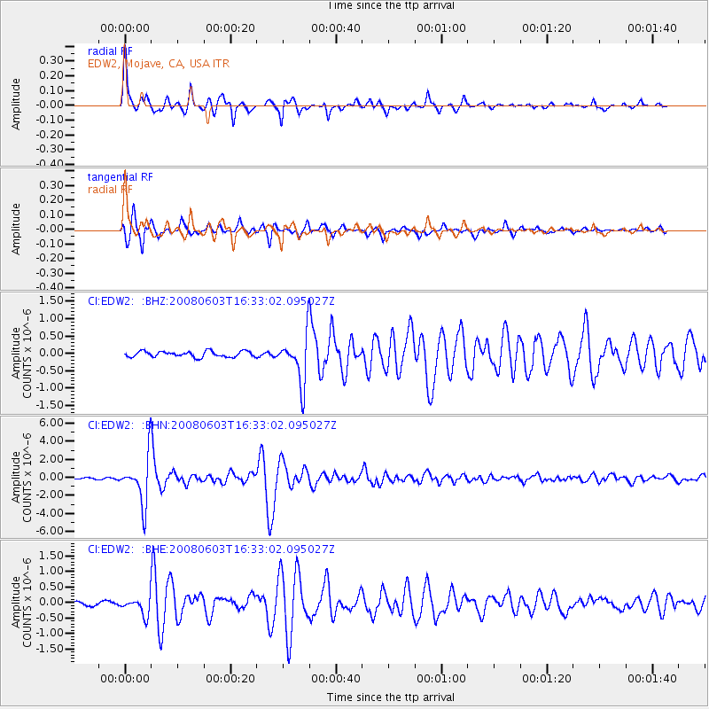
| Radial Match: |
97.12586 % |
| Radial Bump: |
343 |
| Transverse Match: |
95.8012 % |
| Transverse Bump: |
372 |
| SOD ConfigId: |
2504 |
| Insert Time: |
2010-03-05 21:07:17.810 +0000 |
| GWidth: |
2.5 |
| Max Bumps: |
400 |
| Tol: |
0.001 |
|
Signal To Noise
| Channel | StoN | STA | LTA |
| CI:EDW2: :BHN:20080603T16:33:02.095027Z | 39.43872 | 2.6699931E-6 | 6.769979E-8 |
| CI:EDW2: :BHE:20080603T16:33:02.095027Z | 3.9177964 | 2.849657E-7 | 7.273622E-8 |
| CI:EDW2: :BHZ:20080603T16:33:02.095027Z | 8.472949 | 7.030148E-7 | 8.2971674E-8 |
| Arrivals |
| Ps | 4.3 SECOND |
| PpPs | 13 SECOND |
| PsPs/PpSs | 17 SECOND |


