You are here: Home > Network List > CI - Caltech Regional Seismic Network Stations List
> Station EDW2 EDW2, Mojave, CA, USA > Earthquake Result Viewer
EDW2 EDW2, Mojave, CA, USA - Earthquake Result Viewer

| Earthquake location: |
Sea Of Okhotsk |
| Earthquake latitude/longitude: |
53.9/152.9 |
| Earthquake time(UTC): |
2008/07/05 (187) 02:12:04 GMT |
| Earthquake Depth: |
633 km |
| Earthquake Magnitude: |
6.8 MB, 7.7 MW, 7.7 MW |
| Earthquake Catalog/Contributor: |
WHDF/NEIC |
|
| Network: |
CI Caltech Regional Seismic Network |
| Station: |
EDW2 EDW2, Mojave, CA, USA |
| Lat/Lon: |
34.88 N/117.99 W |
| Elevation: |
772 m |
|
| Distance: |
62.2 deg |
| Az: |
68.316 deg |
| Baz: |
317.998 deg |
| Ray Param: |
0.057872973 |
| Estimated Moho Depth: |
32.25 km |
| Estimated Crust Vp/Vs: |
1.69 |
| Assumed Crust Vp: |
6.276 km/s |
| Estimated Crust Vs: |
3.708 km/s |
| Estimated Crust Poisson's Ratio: |
0.23 |
|
| Radial Match: |
95.75744 % |
| Radial Bump: |
346 |
| Transverse Match: |
91.131744 % |
| Transverse Bump: |
400 |
| SOD ConfigId: |
2504 |
| Insert Time: |
2010-03-05 21:07:20.677 +0000 |
| GWidth: |
2.5 |
| Max Bumps: |
400 |
| Tol: |
0.001 |
|
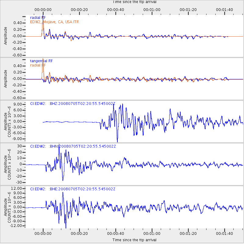
Signal To Noise
| Channel | StoN | STA | LTA |
| CI:EDW2: :BHN:20080705T02:20:55.545002Z | 42.90591 | 4.6938326E-6 | 1.0939827E-7 |
| CI:EDW2: :BHE:20080705T02:20:55.545002Z | 16.93132 | 1.7156586E-6 | 1.0133047E-7 |
| CI:EDW2: :BHZ:20080705T02:20:55.545002Z | 15.932895 | 1.5666495E-6 | 9.8327995E-8 |
| Arrivals |
| Ps | 3.7 SECOND |
| PpPs | 13 SECOND |
| PsPs/PpSs | 17 SECOND |


