You are here: Home > Network List > AK - Alaska Regional Network Stations List
> Station CUT Chulitna, AK, USA > Earthquake Result Viewer
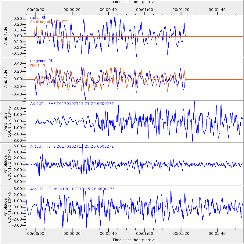
CUT Chulitna, AK, USA - Earthquake Result Viewer
*The percent match for this event was below the threshold and hence no stack was calculated.
| Earthquake location: |
South Of Fiji Islands |
| Earthquake latitude/longitude: |
-23.3/179.3 |
| Earthquake time(UTC): |
2017/01/02 (002) 13:14:02 GMT |
| Earthquake Depth: |
555 km |
| Earthquake Magnitude: |
6.3 Mwb |
| Earthquake Catalog/Contributor: |
NEIC PDE/us |
|
| Network: |
AK Alaska Regional Network |
| Station: |
CUT Chulitna, AK, USA |
| Lat/Lon: |
62.41 N/150.26 W |
| Elevation: |
574 m |
|
| Distance: |
88.8 deg |
| Az: |
13.645 deg |
| Baz: |
207.753 deg |
| Ray Param: |
$rayparam |
*The percent match for this event was below the threshold and hence was not used in the summary stack. |
|
| Radial Match: |
65.12504 % |
| Radial Bump: |
400 |
| Transverse Match: |
63.379375 % |
| Transverse Bump: |
400 |
| SOD ConfigId: |
11737051 |
| Insert Time: |
2019-04-26 12:13:59.991 +0000 |
| GWidth: |
2.5 |
| Max Bumps: |
400 |
| Tol: |
0.001 |
|
Signal To Noise
| Channel | StoN | STA | LTA |
| AK:CUT: :BHZ:20170102T13:25:26.660027Z | 7.5365515 | 1.680362E-6 | 2.2296165E-7 |
| AK:CUT: :BHN:20170102T13:25:26.660027Z | 1.5116165 | 9.660806E-7 | 6.391043E-7 |
| AK:CUT: :BHE:20170102T13:25:26.660027Z | 2.2084405 | 7.509163E-7 | 3.4002107E-7 |
| Arrivals |
| Ps | |
| PpPs | |
| PsPs/PpSs | |


