You are here: Home > Network List > CI - Caltech Regional Seismic Network Stations List
> Station EDW2 EDW2, Mojave, CA, USA > Earthquake Result Viewer
EDW2 EDW2, Mojave, CA, USA - Earthquake Result Viewer
| Earthquake location: |
Solomon Islands |
| Earthquake latitude/longitude: |
-10.9/162.1 |
| Earthquake time(UTC): |
2007/11/27 (331) 11:49:58 GMT |
| Earthquake Depth: |
16 km |
| Earthquake Magnitude: |
5.9 MB, 6.7 MS, 6.6 MW, 6.4 MW |
| Earthquake Catalog/Contributor: |
WHDF/NEIC |
|
| Network: |
CI Caltech Regional Seismic Network |
| Station: |
EDW2 EDW2, Mojave, CA, USA |
| Lat/Lon: |
34.88 N/117.99 W |
| Elevation: |
772 m |
|
| Distance: |
88.0 deg |
| Az: |
54.074 deg |
| Baz: |
255.3 deg |
| Ray Param: |
0.042895027 |
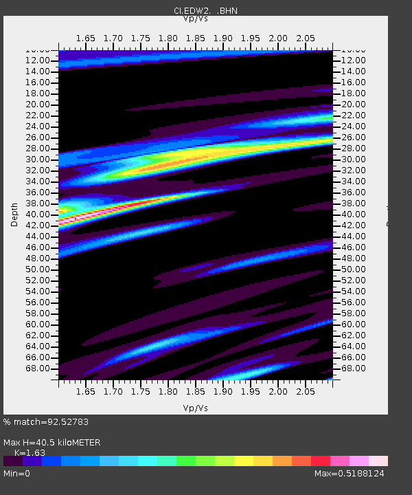
| Estimated Moho Depth: |
40.5 km |
| Estimated Crust Vp/Vs: |
1.63 |
| Assumed Crust Vp: |
6.276 km/s |
| Estimated Crust Vs: |
3.85 km/s |
| Estimated Crust Poisson's Ratio: |
0.20 |
|
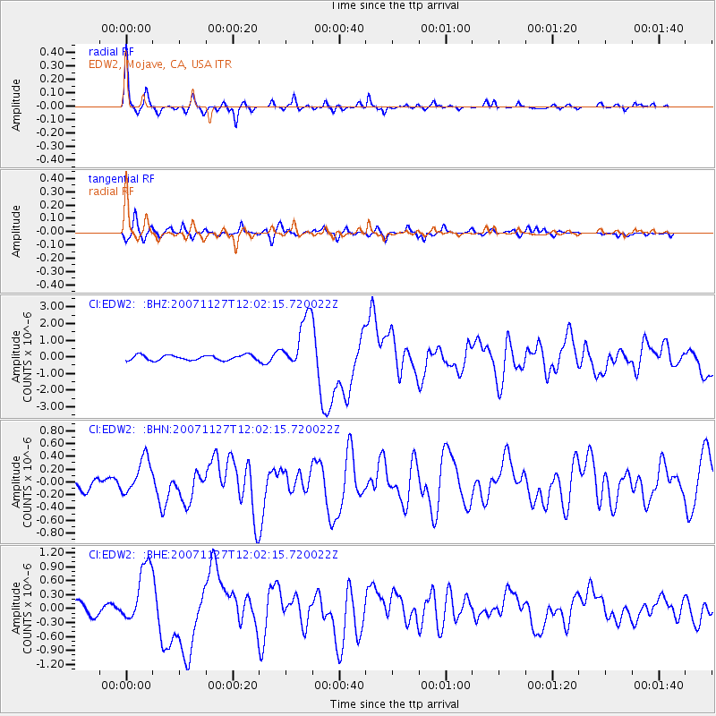
| Radial Match: |
92.52783 % |
| Radial Bump: |
250 |
| Transverse Match: |
66.62375 % |
| Transverse Bump: |
321 |
| SOD ConfigId: |
2564 |
| Insert Time: |
2010-03-05 21:08:07.926 +0000 |
| GWidth: |
2.5 |
| Max Bumps: |
400 |
| Tol: |
0.001 |
|
Signal To Noise
| Channel | StoN | STA | LTA |
| CI:EDW2: :BHN:20071127T12:02:15.720022Z | 2.034223 | 2.8545008E-7 | 1.4032389E-7 |
| CI:EDW2: :BHE:20071127T12:02:15.720022Z | 4.802834 | 6.504858E-7 | 1.354379E-7 |
| CI:EDW2: :BHZ:20071127T12:02:15.720022Z | 10.653083 | 1.6300651E-6 | 1.5301346E-7 |
| Arrivals |
| Ps | 4.2 SECOND |
| PpPs | 17 SECOND |
| PsPs/PpSs | 21 SECOND |


