You are here: Home > Network List > C1 - Red Sismologica Nacional Stations List
> Station LL01 San Ignacio de Huinay > Earthquake Result Viewer
LL01 San Ignacio de Huinay - Earthquake Result Viewer
| Earthquake location: |
South Of Fiji Islands |
| Earthquake latitude/longitude: |
-23.3/179.3 |
| Earthquake time(UTC): |
2017/01/02 (002) 13:14:02 GMT |
| Earthquake Depth: |
555 km |
| Earthquake Magnitude: |
6.3 Mwb |
| Earthquake Catalog/Contributor: |
NEIC PDE/us |
|
| Network: |
C1 Red Sismologica Nacional |
| Station: |
LL01 San Ignacio de Huinay |
| Lat/Lon: |
42.38 S/72.41 W |
| Elevation: |
62 m |
|
| Distance: |
87.1 deg |
| Az: |
135.213 deg |
| Baz: |
240.916 deg |
| Ray Param: |
0.042016134 |
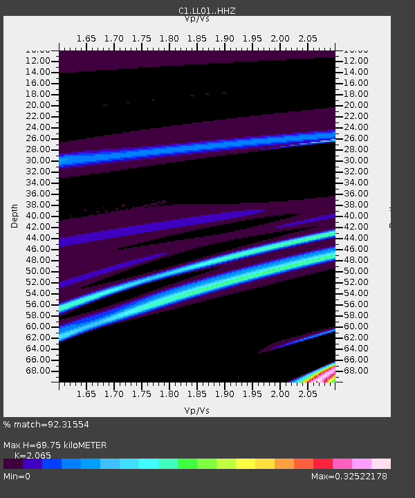
| Estimated Moho Depth: |
69.75 km |
| Estimated Crust Vp/Vs: |
2.07 |
| Assumed Crust Vp: |
6.472 km/s |
| Estimated Crust Vs: |
3.134 km/s |
| Estimated Crust Poisson's Ratio: |
0.35 |
|
| Radial Match: |
92.31554 % |
| Radial Bump: |
90 |
| Transverse Match: |
48.590645 % |
| Transverse Bump: |
400 |
| SOD ConfigId: |
11737051 |
| Insert Time: |
2019-04-26 12:16:05.046 +0000 |
| GWidth: |
2.5 |
| Max Bumps: |
400 |
| Tol: |
0.001 |
|

Signal To Noise
| Channel | StoN | STA | LTA |
| C1:LL01: :HHZ:20170102T13:25:19.379998Z | 1.4740101 | 6.925734E-7 | 4.698566E-7 |
| C1:LL01: :HHN:20170102T13:25:19.379998Z | 0.8645357 | 6.7688245E-7 | 7.8294335E-7 |
| C1:LL01: :HHE:20170102T13:25:19.379998Z | 0.9717462 | 4.9328713E-7 | 5.076296E-7 |
| Arrivals |
| Ps | 12 SECOND |
| PpPs | 32 SECOND |
| PsPs/PpSs | 44 SECOND |


