You are here: Home > Network List > CI - Caltech Regional Seismic Network Stations List
> Station EDW2 EDW2, Mojave, CA, USA > Earthquake Result Viewer
EDW2 EDW2, Mojave, CA, USA - Earthquake Result Viewer
| Earthquake location: |
Solomon Islands |
| Earthquake latitude/longitude: |
-9.8/159.5 |
| Earthquake time(UTC): |
2007/08/16 (228) 08:39:27 GMT |
| Earthquake Depth: |
10 km |
| Earthquake Magnitude: |
6.1 MB, 6.7 MS, 6.4 MW |
| Earthquake Catalog/Contributor: |
WHDF/NEIC |
|
| Network: |
CI Caltech Regional Seismic Network |
| Station: |
EDW2 EDW2, Mojave, CA, USA |
| Lat/Lon: |
34.88 N/117.99 W |
| Elevation: |
772 m |
|
| Distance: |
89.5 deg |
| Az: |
54.608 deg |
| Baz: |
257.742 deg |
| Ray Param: |
0.04180153 |
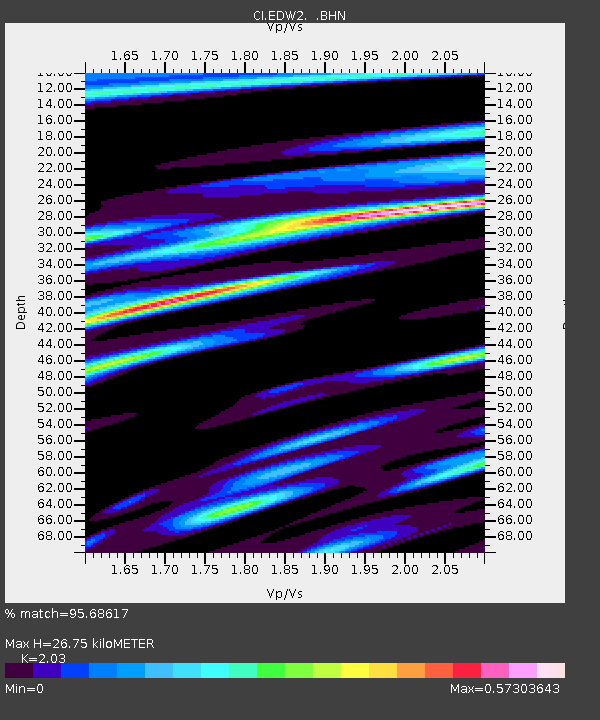
| Estimated Moho Depth: |
26.75 km |
| Estimated Crust Vp/Vs: |
2.03 |
| Assumed Crust Vp: |
6.276 km/s |
| Estimated Crust Vs: |
3.092 km/s |
| Estimated Crust Poisson's Ratio: |
0.34 |
|
| Radial Match: |
95.68617 % |
| Radial Bump: |
316 |
| Transverse Match: |
91.99386 % |
| Transverse Bump: |
373 |
| SOD ConfigId: |
2564 |
| Insert Time: |
2010-03-05 21:08:34.771 +0000 |
| GWidth: |
2.5 |
| Max Bumps: |
400 |
| Tol: |
0.001 |
|
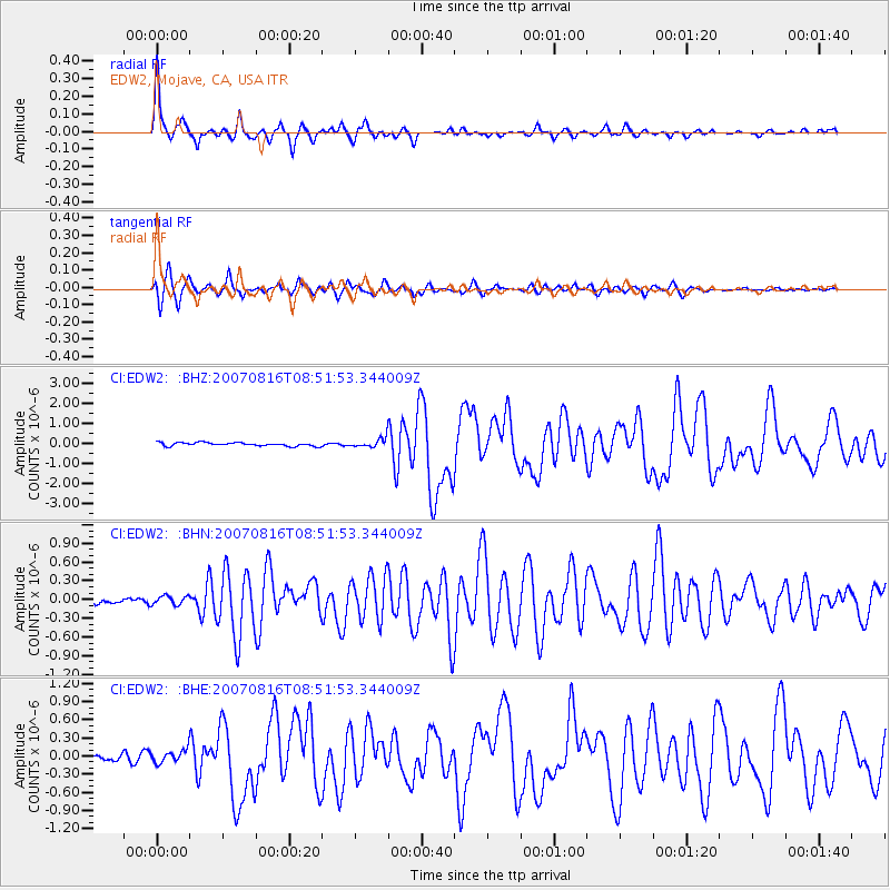
Signal To Noise
| Channel | StoN | STA | LTA |
| CI:EDW2: :BHN:20070816T08:51:53.344009Z | 1.261496 | 6.948511E-8 | 5.5081518E-8 |
| CI:EDW2: :BHE:20070816T08:51:53.344009Z | 1.748587 | 1.0385079E-7 | 5.939126E-8 |
| CI:EDW2: :BHZ:20070816T08:51:53.344009Z | 2.5877168 | 2.2387918E-7 | 8.65161E-8 |
| Arrivals |
| Ps | 4.5 SECOND |
| PpPs | 13 SECOND |
| PsPs/PpSs | 17 SECOND |


