You are here: Home > Network List > IU - Global Seismograph Network (GSN - IRIS/USGS) Stations List
> Station GRFO Grafenberg, Germany > Earthquake Result Viewer
GRFO Grafenberg, Germany - Earthquake Result Viewer
| Earthquake location: |
Hindu Kush Region, Afghanistan |
| Earthquake latitude/longitude: |
36.5/70.9 |
| Earthquake time(UTC): |
2009/10/22 (295) 19:51:27 GMT |
| Earthquake Depth: |
186 km |
| Earthquake Magnitude: |
6.1 MB, 6.2 MW, 6.1 MW |
| Earthquake Catalog/Contributor: |
WHDF/NEIC |
|
| Network: |
IU Global Seismograph Network (GSN - IRIS/USGS) |
| Station: |
GRFO Grafenberg, Germany |
| Lat/Lon: |
49.69 N/11.22 E |
| Elevation: |
384 m |
|
| Distance: |
44.4 deg |
| Az: |
306.736 deg |
| Baz: |
83.767 deg |
| Ray Param: |
0.07121762 |
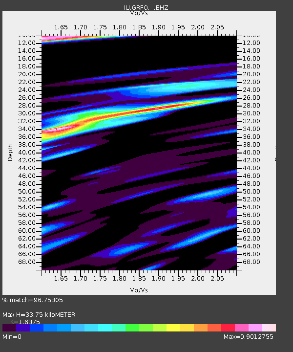
| Estimated Moho Depth: |
33.75 km |
| Estimated Crust Vp/Vs: |
1.64 |
| Assumed Crust Vp: |
6.182 km/s |
| Estimated Crust Vs: |
3.775 km/s |
| Estimated Crust Poisson's Ratio: |
0.20 |
|
| Radial Match: |
96.75805 % |
| Radial Bump: |
362 |
| Transverse Match: |
88.59454 % |
| Transverse Bump: |
374 |
| SOD ConfigId: |
1 |
| Insert Time: |
2010-02-19 00:53:17.493 +0000 |
| GWidth: |
2.5 |
| Max Bumps: |
400 |
| Tol: |
0.001 |
|

Signal To Noise
| Channel | StoN | STA | LTA |
| IU:GRFO: :BHZ:20091022T19:58:49.220012Z | 21.070127 | 4.696797E-6 | 2.229126E-7 |
| IU:GRFO: :BHN:20091022T19:58:49.220012Z | 2.67418 | 5.905776E-7 | 2.2084436E-7 |
| IU:GRFO: :BHE:20091022T19:58:49.220012Z | 8.557337 | 2.609273E-6 | 3.0491648E-7 |
| Arrivals |
| Ps | 3.7 SECOND |
| PpPs | 14 SECOND |
| PsPs/PpSs | 17 SECOND |


