You are here: Home > Network List > CI - Caltech Regional Seismic Network Stations List
> Station EDW2 EDW2, Mojave, CA, USA > Earthquake Result Viewer
EDW2 EDW2, Mojave, CA, USA - Earthquake Result Viewer
| Earthquake location: |
Near West Coast Of Honshu, Japan |
| Earthquake latitude/longitude: |
37.5/138.4 |
| Earthquake time(UTC): |
2007/07/16 (197) 01:13:22 GMT |
| Earthquake Depth: |
12 km |
| Earthquake Magnitude: |
6.5 MB, 6.4 MS, 6.6 MW, 6.5 MW |
| Earthquake Catalog/Contributor: |
WHDF/NEIC |
|
| Network: |
CI Caltech Regional Seismic Network |
| Station: |
EDW2 EDW2, Mojave, CA, USA |
| Lat/Lon: |
34.88 N/117.99 W |
| Elevation: |
772 m |
|
| Distance: |
78.9 deg |
| Az: |
54.527 deg |
| Baz: |
308.051 deg |
| Ray Param: |
0.04930949 |
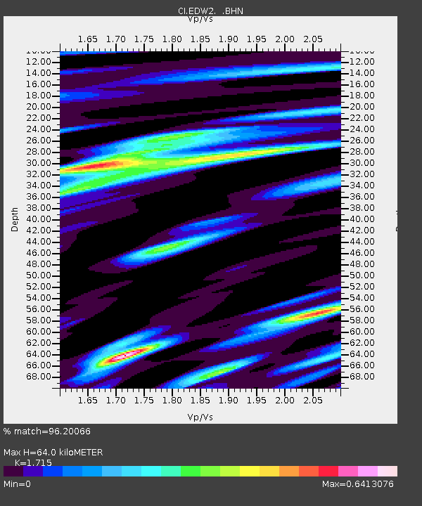
| Estimated Moho Depth: |
64.0 km |
| Estimated Crust Vp/Vs: |
1.72 |
| Assumed Crust Vp: |
6.276 km/s |
| Estimated Crust Vs: |
3.659 km/s |
| Estimated Crust Poisson's Ratio: |
0.24 |
|
| Radial Match: |
96.20066 % |
| Radial Bump: |
339 |
| Transverse Match: |
78.24849 % |
| Transverse Bump: |
371 |
| SOD ConfigId: |
2564 |
| Insert Time: |
2010-03-05 21:08:50.403 +0000 |
| GWidth: |
2.5 |
| Max Bumps: |
400 |
| Tol: |
0.001 |
|
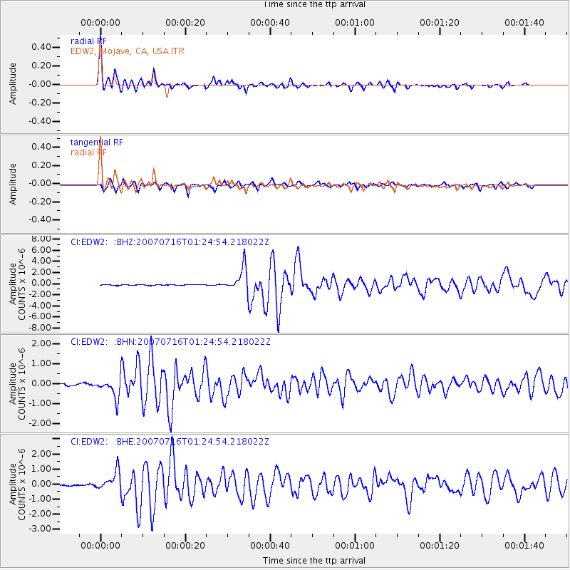
Signal To Noise
| Channel | StoN | STA | LTA |
| CI:EDW2: :BHN:20070716T01:24:54.218022Z | 13.806218 | 5.340998E-7 | 3.8685453E-8 |
| CI:EDW2: :BHE:20070716T01:24:54.218022Z | 14.678845 | 6.6450775E-7 | 4.5269754E-8 |
| CI:EDW2: :BHZ:20070716T01:24:54.218022Z | 35.744198 | 2.2153909E-6 | 6.197904E-8 |
| Arrivals |
| Ps | 7.5 SECOND |
| PpPs | 27 SECOND |
| PsPs/PpSs | 34 SECOND |


