You are here: Home > Network List > TA - USArray Transportable Network (new EarthScope stations) Stations List
> Station J20K Nowitna River, AK, USA > Earthquake Result Viewer
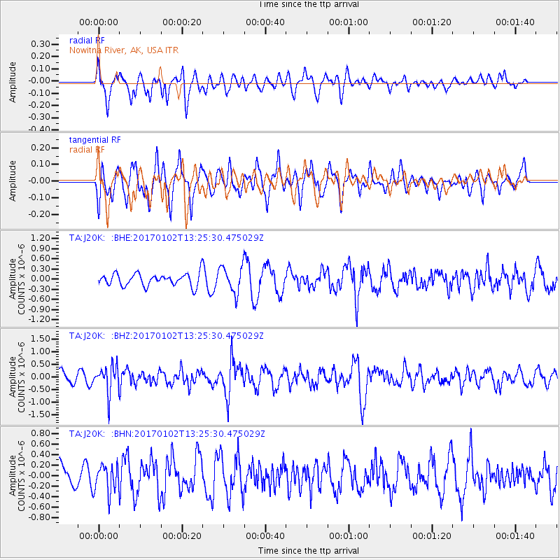
J20K Nowitna River, AK, USA - Earthquake Result Viewer
*The percent match for this event was below the threshold and hence no stack was calculated.
| Earthquake location: |
South Of Fiji Islands |
| Earthquake latitude/longitude: |
-23.3/179.3 |
| Earthquake time(UTC): |
2017/01/02 (002) 13:14:02 GMT |
| Earthquake Depth: |
555 km |
| Earthquake Magnitude: |
6.3 Mwb |
| Earthquake Catalog/Contributor: |
NEIC PDE/us |
|
| Network: |
TA USArray Transportable Network (new EarthScope stations) |
| Station: |
J20K Nowitna River, AK, USA |
| Lat/Lon: |
64.18 N/154.15 W |
| Elevation: |
314 m |
|
| Distance: |
89.7 deg |
| Az: |
11.288 deg |
| Baz: |
204.256 deg |
| Ray Param: |
$rayparam |
*The percent match for this event was below the threshold and hence was not used in the summary stack. |
|
| Radial Match: |
46.596832 % |
| Radial Bump: |
390 |
| Transverse Match: |
53.772152 % |
| Transverse Bump: |
382 |
| SOD ConfigId: |
11737051 |
| Insert Time: |
2019-04-26 12:19:13.786 +0000 |
| GWidth: |
2.5 |
| Max Bumps: |
400 |
| Tol: |
0.001 |
|
Signal To Noise
| Channel | StoN | STA | LTA |
| TA:J20K: :BHZ:20170102T13:25:30.475029Z | 2.359591 | 5.48962E-7 | 2.3265135E-7 |
| TA:J20K: :BHN:20170102T13:25:30.475029Z | 0.92994547 | 2.5496453E-7 | 2.741715E-7 |
| TA:J20K: :BHE:20170102T13:25:30.475029Z | 2.1960435 | 4.0247693E-7 | 1.8327367E-7 |
| Arrivals |
| Ps | |
| PpPs | |
| PsPs/PpSs | |


