You are here: Home > Network List > CI - Caltech Regional Seismic Network Stations List
> Station EDW2 EDW2, Mojave, CA, USA > Earthquake Result Viewer
EDW2 EDW2, Mojave, CA, USA - Earthquake Result Viewer

| Earthquake location: |
Santa Cruz Islands |
| Earthquake latitude/longitude: |
-11.6/166.1 |
| Earthquake time(UTC): |
2009/08/10 (222) 04:06:31 GMT |
| Earthquake Depth: |
35 km |
| Earthquake Magnitude: |
5.8 MB, 6.3 MS, 6.6 MW, 6.6 MW |
| Earthquake Catalog/Contributor: |
WHDF/NEIC |
|
| Network: |
CI Caltech Regional Seismic Network |
| Station: |
EDW2 EDW2, Mojave, CA, USA |
| Lat/Lon: |
34.88 N/117.99 W |
| Elevation: |
772 m |
|
| Distance: |
85.3 deg |
| Az: |
53.142 deg |
| Baz: |
252.472 deg |
| Ray Param: |
0.044825554 |
| Estimated Moho Depth: |
30.5 km |
| Estimated Crust Vp/Vs: |
1.60 |
| Assumed Crust Vp: |
6.276 km/s |
| Estimated Crust Vs: |
3.922 km/s |
| Estimated Crust Poisson's Ratio: |
0.18 |
|
| Radial Match: |
93.26663 % |
| Radial Bump: |
331 |
| Transverse Match: |
71.23438 % |
| Transverse Bump: |
400 |
| SOD ConfigId: |
2622 |
| Insert Time: |
2010-03-05 21:09:28.050 +0000 |
| GWidth: |
2.5 |
| Max Bumps: |
400 |
| Tol: |
0.001 |
|
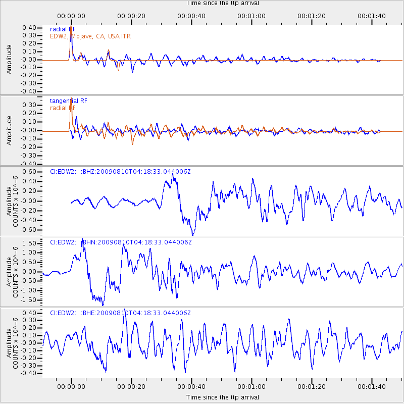
Signal To Noise
| Channel | StoN | STA | LTA |
| CI:EDW2: :BHN:20090810T04:18:33.044006Z | 14.177367 | 9.2646474E-7 | 6.5348154E-8 |
| CI:EDW2: :BHE:20090810T04:18:33.044006Z | 1.3415612 | 1.2116361E-7 | 9.0315375E-8 |
| CI:EDW2: :BHZ:20090810T04:18:33.044006Z | 5.9976597 | 3.549856E-7 | 5.918735E-8 |
| Arrivals |
| Ps | 3.0 SECOND |
| PpPs | 12 SECOND |
| PsPs/PpSs | 15 SECOND |


