You are here: Home > Network List > US - United States National Seismic Network Stations List
> Station AMTX Amarillo, Texas, USA > Earthquake Result Viewer
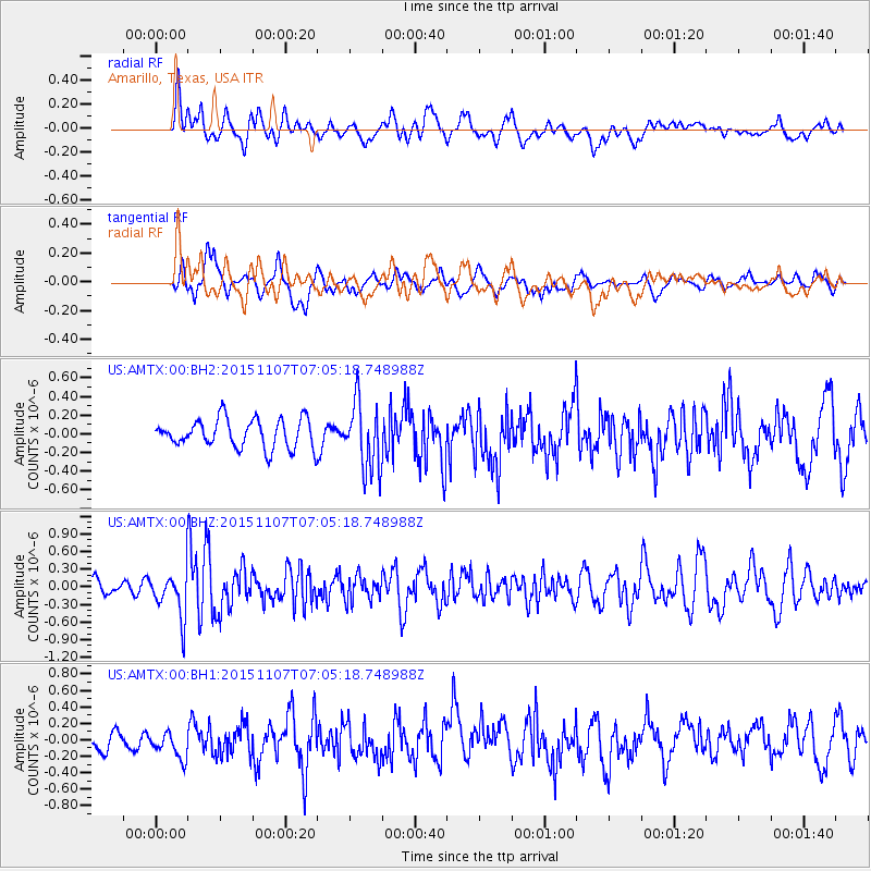
AMTX Amarillo, Texas, USA - Earthquake Result Viewer
*The percent match for this event was below the threshold and hence no stack was calculated.
| Earthquake location: |
Venezuela |
| Earthquake latitude/longitude: |
8.5/-71.4 |
| Earthquake time(UTC): |
2015/11/07 (311) 06:58:30 GMT |
| Earthquake Depth: |
14 km |
| Earthquake Magnitude: |
5.6 MB |
| Earthquake Catalog/Contributor: |
NEIC PDE/NEIC COMCAT |
|
| Network: |
US United States National Seismic Network |
| Station: |
AMTX Amarillo, Texas, USA |
| Lat/Lon: |
34.53 N/101.41 W |
| Elevation: |
1010 m |
|
| Distance: |
37.9 deg |
| Az: |
317.669 deg |
| Baz: |
126.206 deg |
| Ray Param: |
$rayparam |
*The percent match for this event was below the threshold and hence was not used in the summary stack. |
|
| Radial Match: |
58.480522 % |
| Radial Bump: |
400 |
| Transverse Match: |
56.912216 % |
| Transverse Bump: |
400 |
| SOD ConfigId: |
1259291 |
| Insert Time: |
2015-11-21 07:45:18.486 +0000 |
| GWidth: |
2.5 |
| Max Bumps: |
400 |
| Tol: |
0.001 |
|
Signal To Noise
| Channel | StoN | STA | LTA |
| US:AMTX:00:BHZ:20151107T07:05:18.748988Z | 2.6640756 | 3.9922045E-7 | 1.4985328E-7 |
| US:AMTX:00:BH1:20151107T07:05:18.748988Z | 0.7102547 | 1.3750126E-7 | 1.9359429E-7 |
| US:AMTX:00:BH2:20151107T07:05:18.748988Z | 1.5645962 | 2.2779025E-7 | 1.4559045E-7 |
| Arrivals |
| Ps | |
| PpPs | |
| PsPs/PpSs | |


