You are here: Home > Network List > CI - Caltech Regional Seismic Network Stations List
> Station EDW2 EDW2, Mojave, CA, USA > Earthquake Result Viewer
EDW2 EDW2, Mojave, CA, USA - Earthquake Result Viewer
| Earthquake location: |
New Ireland Region, P.N.G. |
| Earthquake latitude/longitude: |
-5.2/153.7 |
| Earthquake time(UTC): |
2009/06/23 (174) 14:19:17 GMT |
| Earthquake Depth: |
65 km |
| Earthquake Magnitude: |
5.5 MB |
| Earthquake Catalog/Contributor: |
WHDF/NEIC |
|
| Network: |
CI Caltech Regional Seismic Network |
| Station: |
EDW2 EDW2, Mojave, CA, USA |
| Lat/Lon: |
34.88 N/117.99 W |
| Elevation: |
772 m |
|
| Distance: |
91.6 deg |
| Az: |
55.294 deg |
| Baz: |
264.792 deg |
| Ray Param: |
0.041568324 |
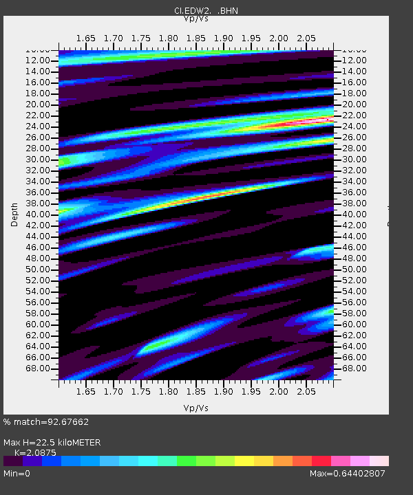
| Estimated Moho Depth: |
22.5 km |
| Estimated Crust Vp/Vs: |
2.09 |
| Assumed Crust Vp: |
6.276 km/s |
| Estimated Crust Vs: |
3.006 km/s |
| Estimated Crust Poisson's Ratio: |
0.35 |
|
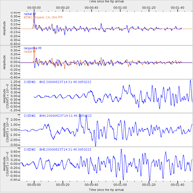
| Radial Match: |
92.67662 % |
| Radial Bump: |
400 |
| Transverse Match: |
82.78013 % |
| Transverse Bump: |
400 |
| SOD ConfigId: |
2648 |
| Insert Time: |
2010-03-05 21:10:16.909 +0000 |
| GWidth: |
2.5 |
| Max Bumps: |
400 |
| Tol: |
0.001 |
|
Signal To Noise
| Channel | StoN | STA | LTA |
| CI:EDW2: :BHN:20090623T14:31:46.095022Z | 1.8736569 | 1.4095907E-7 | 7.523206E-8 |
| CI:EDW2: :BHE:20090623T14:31:46.095022Z | 2.9592078 | 1.7241172E-7 | 5.82628E-8 |
| CI:EDW2: :BHZ:20090623T14:31:46.095022Z | 1.6277168 | 1.2974975E-7 | 7.9712734E-8 |
| Arrivals |
| Ps | 4.0 SECOND |
| PpPs | 11 SECOND |
| PsPs/PpSs | 15 SECOND |


