You are here: Home > Network List > CI - Caltech Regional Seismic Network Stations List
> Station EDW2 EDW2, Mojave, CA, USA > Earthquake Result Viewer
EDW2 EDW2, Mojave, CA, USA - Earthquake Result Viewer
| Earthquake location: |
Kermadec Islands Region |
| Earthquake latitude/longitude: |
-31.8/-179.3 |
| Earthquake time(UTC): |
2006/05/16 (136) 10:39:23 GMT |
| Earthquake Depth: |
152 km |
| Earthquake Magnitude: |
6.8 MB, 7.4 MW, 7.4 MW |
| Earthquake Catalog/Contributor: |
WHDF/NEIC |
|
| Network: |
CI Caltech Regional Seismic Network |
| Station: |
EDW2 EDW2, Mojave, CA, USA |
| Lat/Lon: |
34.88 N/117.99 W |
| Elevation: |
772 m |
|
| Distance: |
87.8 deg |
| Az: |
46.201 deg |
| Baz: |
228.392 deg |
| Ray Param: |
0.042689558 |
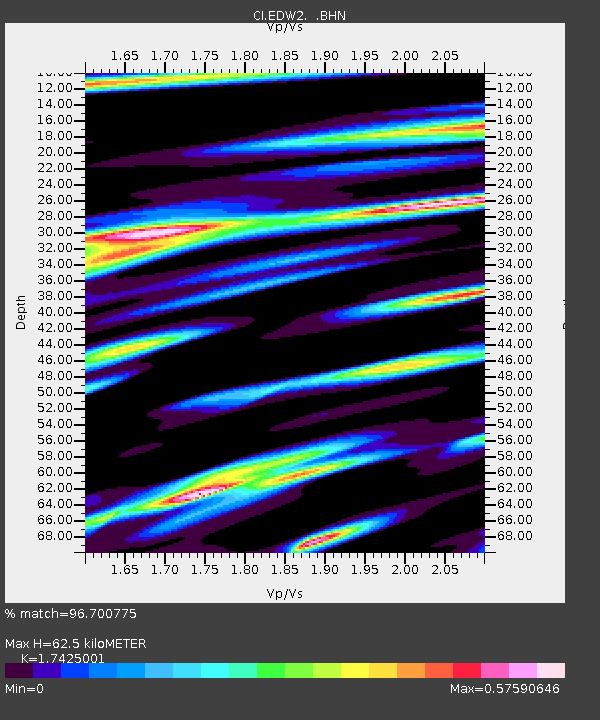
| Estimated Moho Depth: |
62.5 km |
| Estimated Crust Vp/Vs: |
1.74 |
| Assumed Crust Vp: |
6.276 km/s |
| Estimated Crust Vs: |
3.602 km/s |
| Estimated Crust Poisson's Ratio: |
0.25 |
|
| Radial Match: |
96.700775 % |
| Radial Bump: |
345 |
| Transverse Match: |
92.184525 % |
| Transverse Bump: |
400 |
| SOD ConfigId: |
2669 |
| Insert Time: |
2010-03-05 21:10:59.253 +0000 |
| GWidth: |
2.5 |
| Max Bumps: |
400 |
| Tol: |
0.001 |
|

Signal To Noise
| Channel | StoN | STA | LTA |
| CI:EDW2: :BHN:20060516T10:51:24.319004Z | 1.2318336 | 1.9492127E-7 | 1.5823669E-7 |
| CI:EDW2: :BHE:20060516T10:51:24.319004Z | 4.764034 | 3.4119785E-7 | 7.1619525E-8 |
| CI:EDW2: :BHZ:20060516T10:51:24.319004Z | 3.5649614 | 6.961448E-7 | 1.9527414E-7 |
| Arrivals |
| Ps | 7.6 SECOND |
| PpPs | 27 SECOND |
| PsPs/PpSs | 34 SECOND |


