You are here: Home > Network List > AK - Alaska Regional Network Stations List
> Station ANM Anvil Mountian > Earthquake Result Viewer
ANM Anvil Mountian - Earthquake Result Viewer
| Earthquake location: |
South Of Fiji Islands |
| Earthquake latitude/longitude: |
-19.3/176.1 |
| Earthquake time(UTC): |
2017/01/03 (003) 21:52:31 GMT |
| Earthquake Depth: |
17 km |
| Earthquake Magnitude: |
6.9 Mww |
| Earthquake Catalog/Contributor: |
NEIC PDE/us |
|
| Network: |
AK Alaska Regional Network |
| Station: |
ANM Anvil Mountian |
| Lat/Lon: |
64.56 N/165.37 W |
| Elevation: |
330 m |
|
| Distance: |
84.8 deg |
| Az: |
7.942 deg |
| Baz: |
197.583 deg |
| Ray Param: |
0.045181427 |
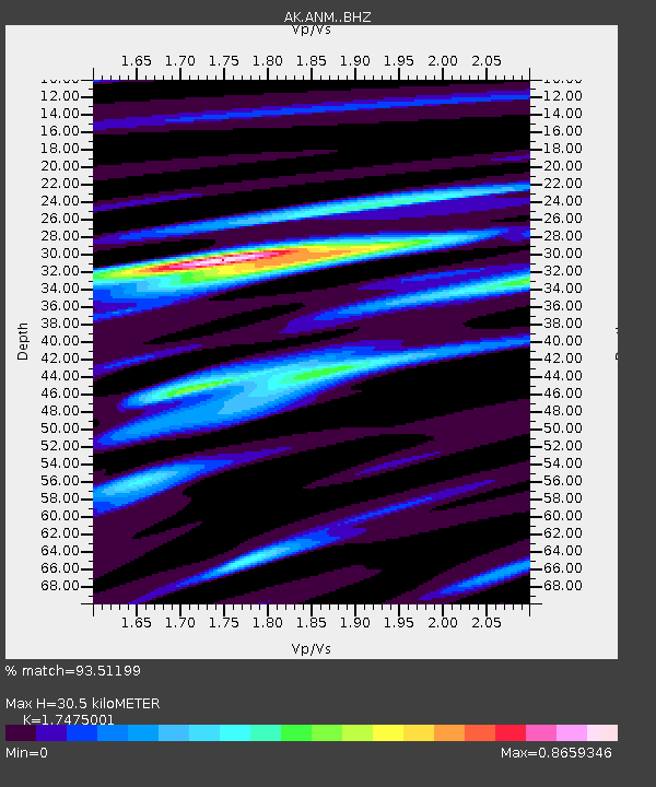
| Estimated Moho Depth: |
30.5 km |
| Estimated Crust Vp/Vs: |
1.75 |
| Assumed Crust Vp: |
6.276 km/s |
| Estimated Crust Vs: |
3.591 km/s |
| Estimated Crust Poisson's Ratio: |
0.26 |
|
| Radial Match: |
93.51199 % |
| Radial Bump: |
400 |
| Transverse Match: |
90.628654 % |
| Transverse Bump: |
400 |
| SOD ConfigId: |
11737051 |
| Insert Time: |
2019-04-26 12:34:42.946 +0000 |
| GWidth: |
2.5 |
| Max Bumps: |
400 |
| Tol: |
0.001 |
|

Signal To Noise
| Channel | StoN | STA | LTA |
| AK:ANM: :BHZ:20170103T22:04:33.727993Z | 32.88886 | 5.69401E-6 | 1.7312885E-7 |
| AK:ANM: :BHN:20170103T22:04:33.727993Z | 13.884347 | 1.9728548E-6 | 1.42092E-7 |
| AK:ANM: :BHE:20170103T22:04:33.727993Z | 3.3941655 | 4.040248E-7 | 1.19035086E-7 |
| Arrivals |
| Ps | 3.7 SECOND |
| PpPs | 13 SECOND |
| PsPs/PpSs | 17 SECOND |


