You are here: Home > Network List > AK - Alaska Regional Network Stations List
> Station CUT Chulitna, AK, USA > Earthquake Result Viewer
CUT Chulitna, AK, USA - Earthquake Result Viewer

| Earthquake location: |
South Of Fiji Islands |
| Earthquake latitude/longitude: |
-19.3/176.1 |
| Earthquake time(UTC): |
2017/01/03 (003) 21:52:31 GMT |
| Earthquake Depth: |
17 km |
| Earthquake Magnitude: |
6.9 Mww |
| Earthquake Catalog/Contributor: |
NEIC PDE/us |
|
| Network: |
AK Alaska Regional Network |
| Station: |
CUT Chulitna, AK, USA |
| Lat/Lon: |
62.41 N/150.26 W |
| Elevation: |
574 m |
|
| Distance: |
85.7 deg |
| Az: |
15.01 deg |
| Baz: |
211.684 deg |
| Ray Param: |
0.044555996 |
| Estimated Moho Depth: |
31.5 km |
| Estimated Crust Vp/Vs: |
1.73 |
| Assumed Crust Vp: |
6.438 km/s |
| Estimated Crust Vs: |
3.722 km/s |
| Estimated Crust Poisson's Ratio: |
0.25 |
|
| Radial Match: |
81.61008 % |
| Radial Bump: |
400 |
| Transverse Match: |
77.52075 % |
| Transverse Bump: |
400 |
| SOD ConfigId: |
11737051 |
| Insert Time: |
2019-04-26 12:34:55.235 +0000 |
| GWidth: |
2.5 |
| Max Bumps: |
400 |
| Tol: |
0.001 |
|
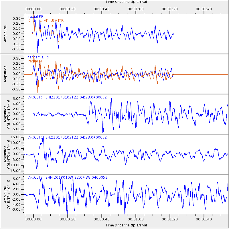
Signal To Noise
| Channel | StoN | STA | LTA |
| AK:CUT: :BHZ:20170103T22:04:38.040005Z | 31.01435 | 6.758714E-6 | 2.1792215E-7 |
| AK:CUT: :BHN:20170103T22:04:38.040005Z | 6.6385007 | 3.2944283E-6 | 4.962609E-7 |
| AK:CUT: :BHE:20170103T22:04:38.040005Z | 6.652635 | 2.6357677E-6 | 3.9619906E-7 |
| Arrivals |
| Ps | 3.7 SECOND |
| PpPs | 13 SECOND |
| PsPs/PpSs | 17 SECOND |


