You are here: Home > Network List > CI - Caltech Regional Seismic Network Stations List
> Station EDW2 EDW2, Mojave, CA, USA > Earthquake Result Viewer
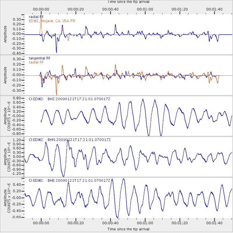
EDW2 EDW2, Mojave, CA, USA - Earthquake Result Viewer
*The percent match for this event was below the threshold and hence no stack was calculated.
| Earthquake location: |
Southeast Of Loyalty Islands |
| Earthquake latitude/longitude: |
-22.7/171.0 |
| Earthquake time(UTC): |
2009/01/21 (021) 17:08:42 GMT |
| Earthquake Depth: |
24 km |
| Earthquake Magnitude: |
5.8 MS, 5.4 MB, 6.1 MW, 6.1 MW |
| Earthquake Catalog/Contributor: |
WHDF/NEIC |
|
| Network: |
CI Caltech Regional Seismic Network |
| Station: |
EDW2 EDW2, Mojave, CA, USA |
| Lat/Lon: |
34.88 N/117.99 W |
| Elevation: |
772 m |
|
| Distance: |
88.3 deg |
| Az: |
51.033 deg |
| Baz: |
240.856 deg |
| Ray Param: |
$rayparam |
*The percent match for this event was below the threshold and hence was not used in the summary stack. |
|
| Radial Match: |
70.1219 % |
| Radial Bump: |
338 |
| Transverse Match: |
64.685715 % |
| Transverse Bump: |
369 |
| SOD ConfigId: |
2834 |
| Insert Time: |
2010-03-05 21:11:38.155 +0000 |
| GWidth: |
2.5 |
| Max Bumps: |
400 |
| Tol: |
0.001 |
|
Signal To Noise
| Channel | StoN | STA | LTA |
| CI:EDW2: :BHN:20090121T17:21:01.070017Z | 1.7826737 | 5.056207E-7 | 2.8363053E-7 |
| CI:EDW2: :BHE:20090121T17:21:01.070017Z | 1.8862311 | 1.9751506E-7 | 1.0471414E-7 |
| CI:EDW2: :BHZ:20090121T17:21:01.070017Z | 1.2174543 | 2.3756259E-7 | 1.9513058E-7 |
| Arrivals |
| Ps | |
| PpPs | |
| PsPs/PpSs | |


