You are here: Home > Network List > AK - Alaska Regional Network Stations List
> Station GHO Gloryhole, AK, USA > Earthquake Result Viewer
GHO Gloryhole, AK, USA - Earthquake Result Viewer
| Earthquake location: |
South Of Fiji Islands |
| Earthquake latitude/longitude: |
-19.3/176.1 |
| Earthquake time(UTC): |
2017/01/03 (003) 21:52:31 GMT |
| Earthquake Depth: |
17 km |
| Earthquake Magnitude: |
6.9 Mww |
| Earthquake Catalog/Contributor: |
NEIC PDE/us |
|
| Network: |
AK Alaska Regional Network |
| Station: |
GHO Gloryhole, AK, USA |
| Lat/Lon: |
61.77 N/148.92 W |
| Elevation: |
1038 m |
|
| Distance: |
85.5 deg |
| Az: |
15.885 deg |
| Baz: |
212.932 deg |
| Ray Param: |
0.0447003 |
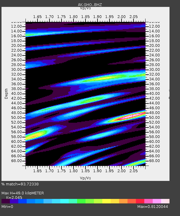
| Estimated Moho Depth: |
49.0 km |
| Estimated Crust Vp/Vs: |
2.05 |
| Assumed Crust Vp: |
6.566 km/s |
| Estimated Crust Vs: |
3.211 km/s |
| Estimated Crust Poisson's Ratio: |
0.34 |
|
| Radial Match: |
93.72338 % |
| Radial Bump: |
400 |
| Transverse Match: |
85.75902 % |
| Transverse Bump: |
400 |
| SOD ConfigId: |
11737051 |
| Insert Time: |
2019-04-26 12:35:03.517 +0000 |
| GWidth: |
2.5 |
| Max Bumps: |
400 |
| Tol: |
0.001 |
|

Signal To Noise
| Channel | StoN | STA | LTA |
| AK:GHO: :BHZ:20170103T22:04:37.027981Z | 26.704052 | 6.0945504E-6 | 2.2822567E-7 |
| AK:GHO: :BHN:20170103T22:04:37.027981Z | 12.317577 | 2.0249993E-6 | 1.6439915E-7 |
| AK:GHO: :BHE:20170103T22:04:37.027981Z | 4.7239337 | 8.9404176E-7 | 1.8925789E-7 |
| Arrivals |
| Ps | 8.0 SECOND |
| PpPs | 22 SECOND |
| PsPs/PpSs | 30 SECOND |


