You are here: Home > Network List > AK - Alaska Regional Network Stations List
> Station GLB Gilahina Butte, AK, USA > Earthquake Result Viewer
GLB Gilahina Butte, AK, USA - Earthquake Result Viewer
| Earthquake location: |
South Of Fiji Islands |
| Earthquake latitude/longitude: |
-19.3/176.1 |
| Earthquake time(UTC): |
2017/01/03 (003) 21:52:31 GMT |
| Earthquake Depth: |
17 km |
| Earthquake Magnitude: |
6.9 Mww |
| Earthquake Catalog/Contributor: |
NEIC PDE/us |
|
| Network: |
AK Alaska Regional Network |
| Station: |
GLB Gilahina Butte, AK, USA |
| Lat/Lon: |
61.44 N/143.81 W |
| Elevation: |
855 m |
|
| Distance: |
86.6 deg |
| Az: |
18.076 deg |
| Baz: |
217.572 deg |
| Ray Param: |
0.04388555 |
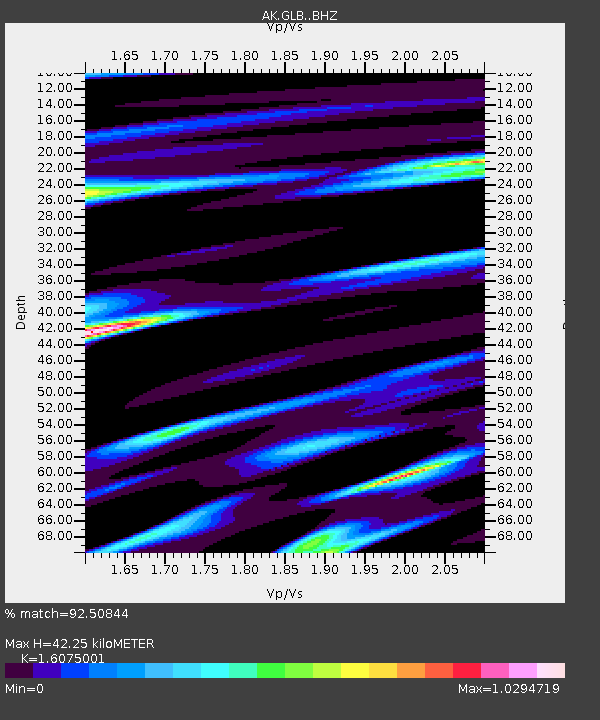
| Estimated Moho Depth: |
42.25 km |
| Estimated Crust Vp/Vs: |
1.61 |
| Assumed Crust Vp: |
6.566 km/s |
| Estimated Crust Vs: |
4.085 km/s |
| Estimated Crust Poisson's Ratio: |
0.18 |
|
| Radial Match: |
92.50844 % |
| Radial Bump: |
354 |
| Transverse Match: |
86.12405 % |
| Transverse Bump: |
400 |
| SOD ConfigId: |
11737051 |
| Insert Time: |
2019-04-26 12:35:03.967 +0000 |
| GWidth: |
2.5 |
| Max Bumps: |
400 |
| Tol: |
0.001 |
|

Signal To Noise
| Channel | StoN | STA | LTA |
| AK:GLB: :BHZ:20170103T22:04:42.628018Z | 29.637106 | 4.345434E-6 | 1.466214E-7 |
| AK:GLB: :BHN:20170103T22:04:42.628018Z | 6.914921 | 1.3478025E-6 | 1.949122E-7 |
| AK:GLB: :BHE:20170103T22:04:42.628018Z | 7.253207 | 9.980096E-7 | 1.3759562E-7 |
| Arrivals |
| Ps | 4.0 SECOND |
| PpPs | 16 SECOND |
| PsPs/PpSs | 20 SECOND |


