You are here: Home > Network List > AK - Alaska Regional Network Stations List
> Station KIAG Kiagna River, AK, USA > Earthquake Result Viewer
KIAG Kiagna River, AK, USA - Earthquake Result Viewer
| Earthquake location: |
South Of Fiji Islands |
| Earthquake latitude/longitude: |
-19.3/176.1 |
| Earthquake time(UTC): |
2017/01/03 (003) 21:52:31 GMT |
| Earthquake Depth: |
17 km |
| Earthquake Magnitude: |
6.9 Mww |
| Earthquake Catalog/Contributor: |
NEIC PDE/us |
|
| Network: |
AK Alaska Regional Network |
| Station: |
KIAG Kiagna River, AK, USA |
| Lat/Lon: |
60.92 N/142.36 W |
| Elevation: |
1773 m |
|
| Distance: |
86.7 deg |
| Az: |
18.952 deg |
| Baz: |
218.893 deg |
| Ray Param: |
0.043866172 |
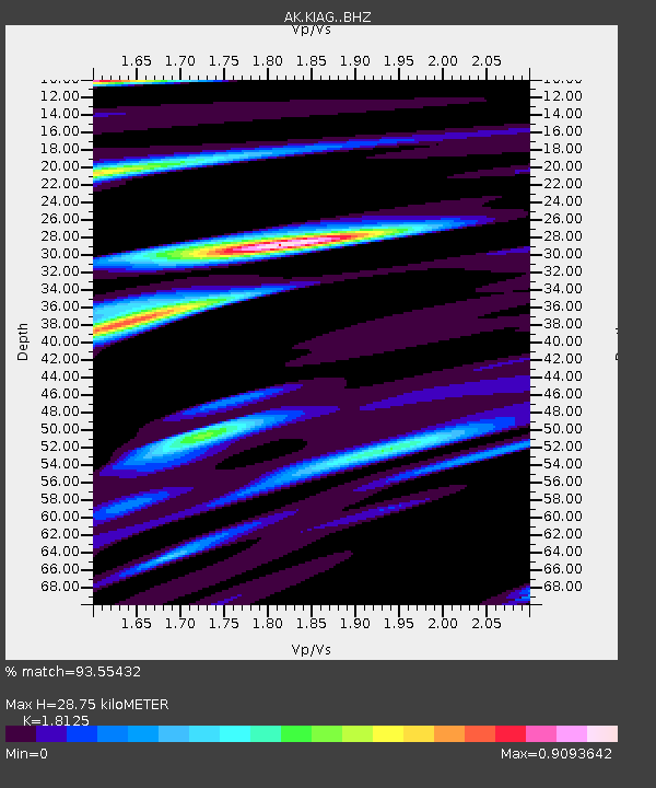
| Estimated Moho Depth: |
28.75 km |
| Estimated Crust Vp/Vs: |
1.81 |
| Assumed Crust Vp: |
6.566 km/s |
| Estimated Crust Vs: |
3.623 km/s |
| Estimated Crust Poisson's Ratio: |
0.28 |
|
| Radial Match: |
93.55432 % |
| Radial Bump: |
400 |
| Transverse Match: |
89.381676 % |
| Transverse Bump: |
400 |
| SOD ConfigId: |
11737051 |
| Insert Time: |
2019-04-26 12:35:08.419 +0000 |
| GWidth: |
2.5 |
| Max Bumps: |
400 |
| Tol: |
0.001 |
|

Signal To Noise
| Channel | StoN | STA | LTA |
| AK:KIAG: :BHZ:20170103T22:04:42.767971Z | 22.42087 | 4.734304E-6 | 2.1115613E-7 |
| AK:KIAG: :BHN:20170103T22:04:42.767971Z | 8.289127 | 1.4785832E-6 | 1.7837623E-7 |
| AK:KIAG: :BHE:20170103T22:04:42.767971Z | 5.699941 | 1.1668049E-6 | 2.0470473E-7 |
| Arrivals |
| Ps | 3.6 SECOND |
| PpPs | 12 SECOND |
| PsPs/PpSs | 16 SECOND |


