You are here: Home > Network List > AT - Alaska Tsunami Warning Seismic System Stations List
> Station CRAG Craig, Alaska > Earthquake Result Viewer
CRAG Craig, Alaska - Earthquake Result Viewer
| Earthquake location: |
South Of Fiji Islands |
| Earthquake latitude/longitude: |
-19.3/176.1 |
| Earthquake time(UTC): |
2017/01/03 (003) 21:52:31 GMT |
| Earthquake Depth: |
17 km |
| Earthquake Magnitude: |
6.9 Mww |
| Earthquake Catalog/Contributor: |
NEIC PDE/us |
|
| Network: |
AT Alaska Tsunami Warning Seismic System |
| Station: |
CRAG Craig, Alaska |
| Lat/Lon: |
55.47 N/133.12 W |
| Elevation: |
58 m |
|
| Distance: |
86.0 deg |
| Az: |
26.263 deg |
| Baz: |
227.209 deg |
| Ray Param: |
0.04433089 |
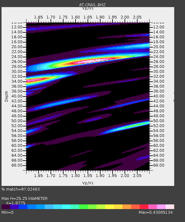
| Estimated Moho Depth: |
25.25 km |
| Estimated Crust Vp/Vs: |
1.88 |
| Assumed Crust Vp: |
6.472 km/s |
| Estimated Crust Vs: |
3.447 km/s |
| Estimated Crust Poisson's Ratio: |
0.30 |
|
| Radial Match: |
97.02483 % |
| Radial Bump: |
214 |
| Transverse Match: |
87.04801 % |
| Transverse Bump: |
400 |
| SOD ConfigId: |
11737051 |
| Insert Time: |
2019-04-26 12:35:36.670 +0000 |
| GWidth: |
2.5 |
| Max Bumps: |
400 |
| Tol: |
0.001 |
|

Signal To Noise
| Channel | StoN | STA | LTA |
| AT:CRAG: :BHZ:20170103T22:04:39.579983Z | 11.439028 | 3.6453914E-6 | 3.1868018E-7 |
| AT:CRAG: :BHN:20170103T22:04:39.579983Z | 9.057864 | 1.3061979E-6 | 1.4420593E-7 |
| AT:CRAG: :BHE:20170103T22:04:39.579983Z | 11.519422 | 2.5224097E-6 | 2.1897016E-7 |
| Arrivals |
| Ps | 3.5 SECOND |
| PpPs | 11 SECOND |
| PsPs/PpSs | 14 SECOND |


