You are here: Home > Network List > AV - Alaska Volcano Observatory Stations List
> Station AUCH Augustine Cone H, Augustine Volcano, Alaska > Earthquake Result Viewer
AUCH Augustine Cone H, Augustine Volcano, Alaska - Earthquake Result Viewer
| Earthquake location: |
South Of Fiji Islands |
| Earthquake latitude/longitude: |
-19.3/176.1 |
| Earthquake time(UTC): |
2017/01/03 (003) 21:52:31 GMT |
| Earthquake Depth: |
17 km |
| Earthquake Magnitude: |
6.9 Mww |
| Earthquake Catalog/Contributor: |
NEIC PDE/us |
|
| Network: |
AV Alaska Volcano Observatory |
| Station: |
AUCH Augustine Cone H, Augustine Volcano, Alaska |
| Lat/Lon: |
59.36 N/153.44 W |
| Elevation: |
916 m |
|
| Distance: |
82.3 deg |
| Az: |
15.208 deg |
| Baz: |
208.927 deg |
| Ray Param: |
0.046977032 |
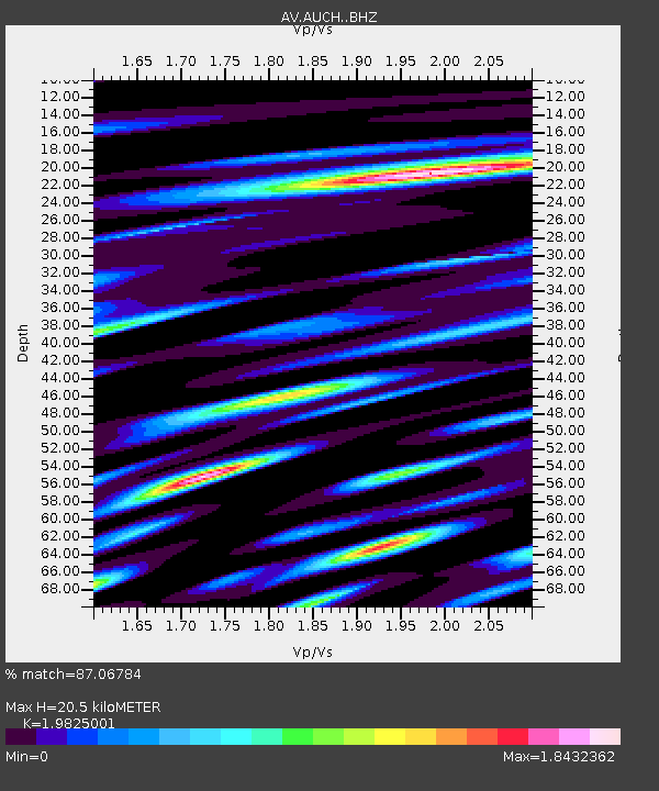
| Estimated Moho Depth: |
20.5 km |
| Estimated Crust Vp/Vs: |
1.98 |
| Assumed Crust Vp: |
5.989 km/s |
| Estimated Crust Vs: |
3.021 km/s |
| Estimated Crust Poisson's Ratio: |
0.33 |
|
| Radial Match: |
87.06784 % |
| Radial Bump: |
400 |
| Transverse Match: |
82.65809 % |
| Transverse Bump: |
400 |
| SOD ConfigId: |
11737051 |
| Insert Time: |
2019-04-26 12:36:05.969 +0000 |
| GWidth: |
2.5 |
| Max Bumps: |
400 |
| Tol: |
0.001 |
|

Signal To Noise
| Channel | StoN | STA | LTA |
| AV:AUCH: :BHZ:20170103T22:04:20.660Z | 17.096592 | 1.0178133E-5 | 5.953312E-7 |
| AV:AUCH: :BHN:20170103T22:04:20.660Z | 2.9546216 | 4.444356E-6 | 1.5042049E-6 |
| AV:AUCH: :BHE:20170103T22:04:20.660Z | 1.7250334 | 1.8512463E-6 | 1.0731655E-6 |
| Arrivals |
| Ps | 3.4 SECOND |
| PpPs | 10 SECOND |
| PsPs/PpSs | 13 SECOND |


