You are here: Home > Network List > AV - Alaska Volcano Observatory Stations List
> Station AUJA Augustine Junction, Augustine Volcano, Alaska > Earthquake Result Viewer
AUJA Augustine Junction, Augustine Volcano, Alaska - Earthquake Result Viewer
| Earthquake location: |
South Of Fiji Islands |
| Earthquake latitude/longitude: |
-19.3/176.1 |
| Earthquake time(UTC): |
2017/01/03 (003) 21:52:31 GMT |
| Earthquake Depth: |
17 km |
| Earthquake Magnitude: |
6.9 Mww |
| Earthquake Catalog/Contributor: |
NEIC PDE/us |
|
| Network: |
AV Alaska Volcano Observatory |
| Station: |
AUJA Augustine Junction, Augustine Volcano, Alaska |
| Lat/Lon: |
59.34 N/153.42 W |
| Elevation: |
376 m |
|
| Distance: |
82.3 deg |
| Az: |
15.229 deg |
| Baz: |
208.949 deg |
| Ray Param: |
0.046987303 |
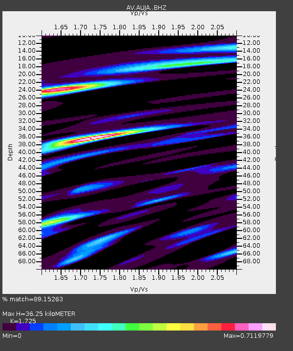
| Estimated Moho Depth: |
36.25 km |
| Estimated Crust Vp/Vs: |
1.73 |
| Assumed Crust Vp: |
5.989 km/s |
| Estimated Crust Vs: |
3.472 km/s |
| Estimated Crust Poisson's Ratio: |
0.25 |
|
| Radial Match: |
89.15263 % |
| Radial Bump: |
400 |
| Transverse Match: |
78.809296 % |
| Transverse Bump: |
400 |
| SOD ConfigId: |
11737051 |
| Insert Time: |
2019-04-26 12:36:07.035 +0000 |
| GWidth: |
2.5 |
| Max Bumps: |
400 |
| Tol: |
0.001 |
|
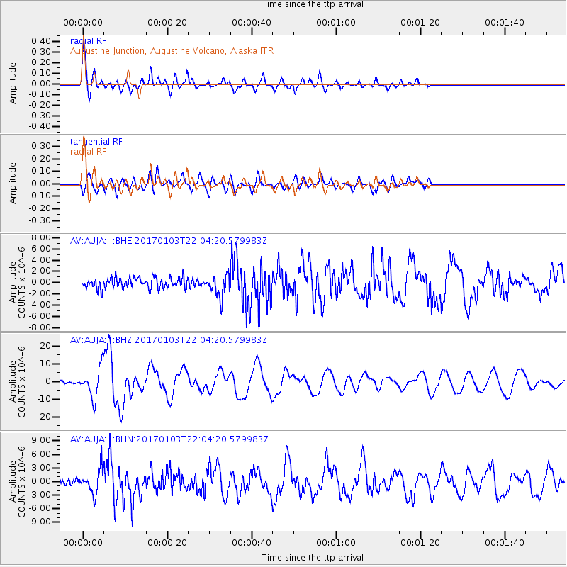
Signal To Noise
| Channel | StoN | STA | LTA |
| AV:AUJA: :BHZ:20170103T22:04:20.579983Z | 22.273506 | 8.449372E-6 | 3.7934632E-7 |
| AV:AUJA: :BHN:20170103T22:04:20.579983Z | 5.8290854 | 2.7846133E-6 | 4.7771016E-7 |
| AV:AUJA: :BHE:20170103T22:04:20.579983Z | 2.039797 | 1.8690072E-6 | 9.162712E-7 |
| Arrivals |
| Ps | 4.5 SECOND |
| PpPs | 16 SECOND |
| PsPs/PpSs | 21 SECOND |


