You are here: Home > Network List > AV - Alaska Volcano Observatory Stations List
> Station AUSS Augustine Summit Station, Augustine Volcano, Alaska > Earthquake Result Viewer
AUSS Augustine Summit Station, Augustine Volcano, Alaska - Earthquake Result Viewer
| Earthquake location: |
South Of Fiji Islands |
| Earthquake latitude/longitude: |
-19.3/176.1 |
| Earthquake time(UTC): |
2017/01/03 (003) 21:52:31 GMT |
| Earthquake Depth: |
17 km |
| Earthquake Magnitude: |
6.9 Mww |
| Earthquake Catalog/Contributor: |
NEIC PDE/us |
|
| Network: |
AV Alaska Volcano Observatory |
| Station: |
AUSS Augustine Summit Station, Augustine Volcano, Alaska |
| Lat/Lon: |
59.36 N/153.43 W |
| Elevation: |
1235 m |
|
| Distance: |
82.3 deg |
| Az: |
15.216 deg |
| Baz: |
208.94 deg |
| Ray Param: |
0.04697691 |
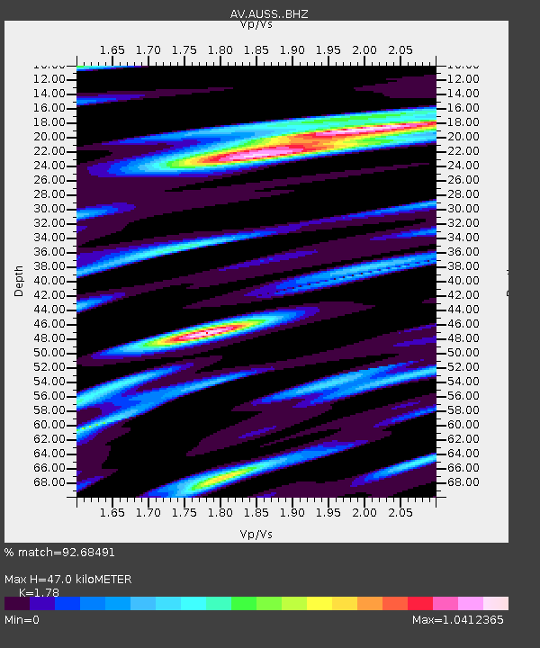
| Estimated Moho Depth: |
47.0 km |
| Estimated Crust Vp/Vs: |
1.78 |
| Assumed Crust Vp: |
5.989 km/s |
| Estimated Crust Vs: |
3.365 km/s |
| Estimated Crust Poisson's Ratio: |
0.27 |
|
| Radial Match: |
92.68491 % |
| Radial Bump: |
400 |
| Transverse Match: |
91.75374 % |
| Transverse Bump: |
400 |
| SOD ConfigId: |
11737051 |
| Insert Time: |
2019-04-26 12:36:08.221 +0000 |
| GWidth: |
2.5 |
| Max Bumps: |
400 |
| Tol: |
0.001 |
|
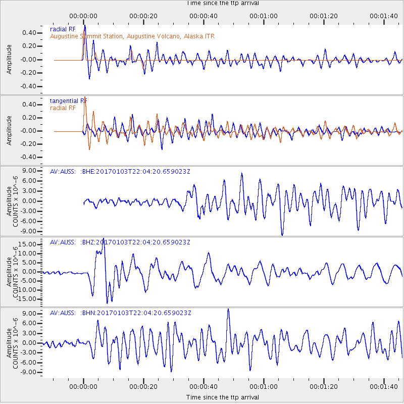
Signal To Noise
| Channel | StoN | STA | LTA |
| AV:AUSS: :BHZ:20170103T22:04:20.659023Z | 18.318872 | 6.5598156E-6 | 3.5809057E-7 |
| AV:AUSS: :BHN:20170103T22:04:20.659023Z | 4.5464535 | 2.7829456E-6 | 6.121135E-7 |
| AV:AUSS: :BHE:20170103T22:04:20.659023Z | 2.07951 | 1.3253613E-6 | 6.373431E-7 |
| Arrivals |
| Ps | 6.3 SECOND |
| PpPs | 21 SECOND |
| PsPs/PpSs | 28 SECOND |


