You are here: Home > Network List > AV - Alaska Volcano Observatory Stations List
> Station ISLZ Lazaref River, Shishaldin Volcano, Alaska > Earthquake Result Viewer
ISLZ Lazaref River, Shishaldin Volcano, Alaska - Earthquake Result Viewer
| Earthquake location: |
South Of Fiji Islands |
| Earthquake latitude/longitude: |
-19.3/176.1 |
| Earthquake time(UTC): |
2017/01/03 (003) 21:52:31 GMT |
| Earthquake Depth: |
17 km |
| Earthquake Magnitude: |
6.9 Mww |
| Earthquake Catalog/Contributor: |
NEIC PDE/us |
|
| Network: |
AV Alaska Volcano Observatory |
| Station: |
ISLZ Lazaref River, Shishaldin Volcano, Alaska |
| Lat/Lon: |
54.72 N/163.71 W |
| Elevation: |
634 m |
|
| Distance: |
75.8 deg |
| Az: |
11.946 deg |
| Baz: |
199.693 deg |
| Ray Param: |
0.051439982 |
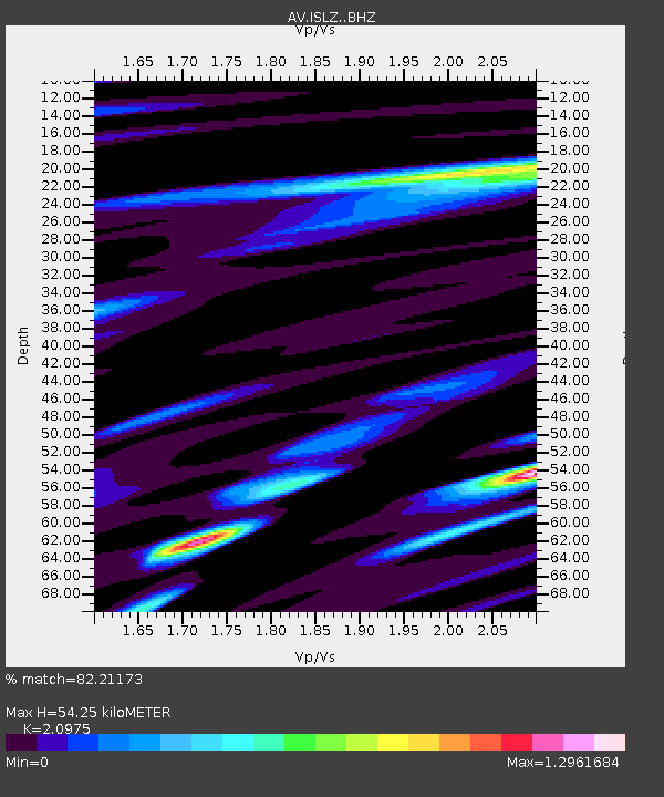
| Estimated Moho Depth: |
54.25 km |
| Estimated Crust Vp/Vs: |
2.10 |
| Assumed Crust Vp: |
5.989 km/s |
| Estimated Crust Vs: |
2.855 km/s |
| Estimated Crust Poisson's Ratio: |
0.35 |
|
| Radial Match: |
82.21173 % |
| Radial Bump: |
400 |
| Transverse Match: |
66.36073 % |
| Transverse Bump: |
400 |
| SOD ConfigId: |
11737051 |
| Insert Time: |
2019-04-26 12:36:13.089 +0000 |
| GWidth: |
2.5 |
| Max Bumps: |
400 |
| Tol: |
0.001 |
|

Signal To Noise
| Channel | StoN | STA | LTA |
| AV:ISLZ: :BHZ:20170103T22:03:45.019009Z | 6.3769717 | 3.7478258E-6 | 5.8771246E-7 |
| AV:ISLZ: :BHN:20170103T22:03:45.019009Z | 2.7138743 | 1.5222652E-6 | 5.6091955E-7 |
| AV:ISLZ: :BHE:20170103T22:03:45.019009Z | 1.5633003 | 1.1010992E-6 | 7.0434277E-7 |
| Arrivals |
| Ps | 10 SECOND |
| PpPs | 27 SECOND |
| PsPs/PpSs | 38 SECOND |


