You are here: Home > Network List > AZ - ANZA Regional Network Stations List
> Station SMER AZ.SMER > Earthquake Result Viewer
SMER AZ.SMER - Earthquake Result Viewer
| Earthquake location: |
South Of Fiji Islands |
| Earthquake latitude/longitude: |
-19.3/176.1 |
| Earthquake time(UTC): |
2017/01/03 (003) 21:52:31 GMT |
| Earthquake Depth: |
17 km |
| Earthquake Magnitude: |
6.9 Mww |
| Earthquake Catalog/Contributor: |
NEIC PDE/us |
|
| Network: |
AZ ANZA Regional Network |
| Station: |
SMER AZ.SMER |
| Lat/Lon: |
33.46 N/117.17 W |
| Elevation: |
355 m |
|
| Distance: |
82.5 deg |
| Az: |
50.797 deg |
| Baz: |
241.086 deg |
| Ray Param: |
0.04684189 |
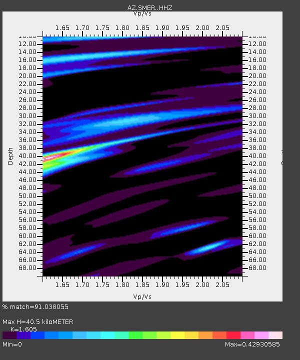
| Estimated Moho Depth: |
40.5 km |
| Estimated Crust Vp/Vs: |
1.61 |
| Assumed Crust Vp: |
6.264 km/s |
| Estimated Crust Vs: |
3.903 km/s |
| Estimated Crust Poisson's Ratio: |
0.18 |
|
| Radial Match: |
91.038055 % |
| Radial Bump: |
273 |
| Transverse Match: |
84.14934 % |
| Transverse Bump: |
399 |
| SOD ConfigId: |
11737051 |
| Insert Time: |
2019-04-26 12:36:33.705 +0000 |
| GWidth: |
2.5 |
| Max Bumps: |
400 |
| Tol: |
0.001 |
|
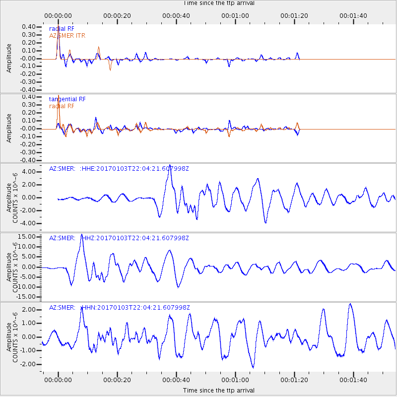
Signal To Noise
| Channel | StoN | STA | LTA |
| AZ:SMER: :HHZ:20170103T22:04:21.607998Z | 12.41621 | 3.292785E-6 | 2.652005E-7 |
| AZ:SMER: :HHN:20170103T22:04:21.607998Z | 1.9079965 | 5.4606187E-7 | 2.8619647E-7 |
| AZ:SMER: :HHE:20170103T22:04:21.607998Z | 3.5816293 | 1.1121433E-6 | 3.1051323E-7 |
| Arrivals |
| Ps | 4.0 SECOND |
| PpPs | 16 SECOND |
| PsPs/PpSs | 20 SECOND |


