You are here: Home > Network List > C1 - Red Sismologica Nacional Stations List
> Station MT01 Daracena > Earthquake Result Viewer
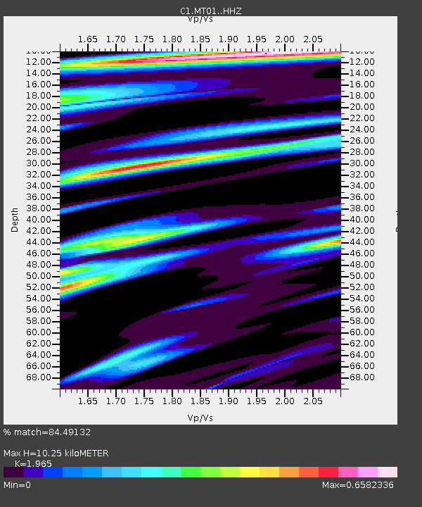
MT01 Daracena - Earthquake Result Viewer
| Earthquake location: |
South Of Fiji Islands |
| Earthquake latitude/longitude: |
-19.3/176.1 |
| Earthquake time(UTC): |
2017/01/03 (003) 21:52:31 GMT |
| Earthquake Depth: |
17 km |
| Earthquake Magnitude: |
6.9 Mww |
| Earthquake Catalog/Contributor: |
NEIC PDE/us |
|
| Network: |
C1 Red Sismologica Nacional |
| Station: |
MT01 Daracena |
| Lat/Lon: |
33.86 S/71.25 W |
| Elevation: |
310 m |
|
| Distance: |
96.9 deg |
| Az: |
129.348 deg |
| Baz: |
241.358 deg |
| Ray Param: |
0.04036145 |
| Estimated Moho Depth: |
10.25 km |
| Estimated Crust Vp/Vs: |
1.97 |
| Assumed Crust Vp: |
6.481 km/s |
| Estimated Crust Vs: |
3.298 km/s |
| Estimated Crust Poisson's Ratio: |
0.33 |
|
| Radial Match: |
84.49132 % |
| Radial Bump: |
359 |
| Transverse Match: |
68.77387 % |
| Transverse Bump: |
400 |
| SOD ConfigId: |
11737051 |
| Insert Time: |
2019-04-26 12:37:02.469 +0000 |
| GWidth: |
2.5 |
| Max Bumps: |
400 |
| Tol: |
0.001 |
|

Signal To Noise
| Channel | StoN | STA | LTA |
| C1:MT01: :HHZ:20170103T22:05:29.980007Z | 2.1200783 | 6.913263E-7 | 3.2608526E-7 |
| C1:MT01: :HHN:20170103T22:05:29.980007Z | 1.5370263 | 3.0689606E-7 | 1.9966872E-7 |
| C1:MT01: :HHE:20170103T22:05:29.980007Z | 2.0591514 | 3.393613E-7 | 1.6480638E-7 |
| Arrivals |
| Ps | 1.6 SECOND |
| PpPs | 4.6 SECOND |
| PsPs/PpSs | 6.2 SECOND |


