You are here: Home > Network List > CB - China National Seismic Network Stations List
> Station CD2 Chengdou,Sichuan Province > Earthquake Result Viewer
CD2 Chengdou,Sichuan Province - Earthquake Result Viewer
| Earthquake location: |
South Of Fiji Islands |
| Earthquake latitude/longitude: |
-19.3/176.1 |
| Earthquake time(UTC): |
2017/01/03 (003) 21:52:31 GMT |
| Earthquake Depth: |
17 km |
| Earthquake Magnitude: |
6.9 Mww |
| Earthquake Catalog/Contributor: |
NEIC PDE/us |
|
| Network: |
CB China National Seismic Network |
| Station: |
CD2 Chengdou,Sichuan Province |
| Lat/Lon: |
30.91 N/103.76 E |
| Elevation: |
653 m |
|
| Distance: |
85.5 deg |
| Az: |
304.782 deg |
| Baz: |
115.523 deg |
| Ray Param: |
0.044716977 |
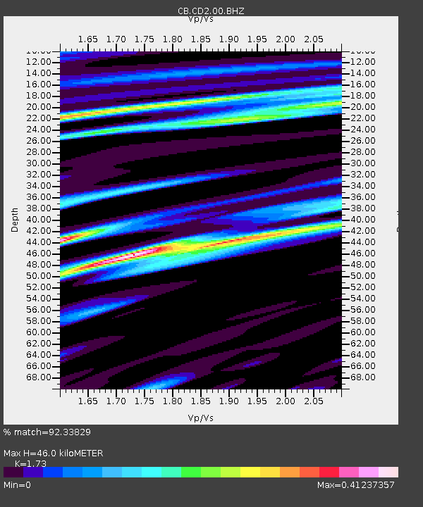
| Estimated Moho Depth: |
46.0 km |
| Estimated Crust Vp/Vs: |
1.73 |
| Assumed Crust Vp: |
6.159 km/s |
| Estimated Crust Vs: |
3.56 km/s |
| Estimated Crust Poisson's Ratio: |
0.25 |
|
| Radial Match: |
92.33829 % |
| Radial Bump: |
350 |
| Transverse Match: |
82.48782 % |
| Transverse Bump: |
400 |
| SOD ConfigId: |
11737051 |
| Insert Time: |
2019-04-26 12:37:08.754 +0000 |
| GWidth: |
2.5 |
| Max Bumps: |
400 |
| Tol: |
0.001 |
|

Signal To Noise
| Channel | StoN | STA | LTA |
| CB:CD2:00:BHZ:20170103T22:04:36.88998Z | 59.71868 | 8.175858E-6 | 1.3690621E-7 |
| CB:CD2:00:BHN:20170103T22:04:36.88998Z | 6.9446793 | 1.0043962E-6 | 1.4462815E-7 |
| CB:CD2:00:BHE:20170103T22:04:36.88998Z | 12.806376 | 1.6903546E-6 | 1.3199319E-7 |
| Arrivals |
| Ps | 5.6 SECOND |
| PpPs | 20 SECOND |
| PsPs/PpSs | 26 SECOND |


