You are here: Home > Network List > CB - China National Seismic Network Stations List
> Station GYA Guiyang,Yunnan Province > Earthquake Result Viewer
GYA Guiyang,Yunnan Province - Earthquake Result Viewer
| Earthquake location: |
South Of Fiji Islands |
| Earthquake latitude/longitude: |
-19.3/176.1 |
| Earthquake time(UTC): |
2017/01/03 (003) 21:52:31 GMT |
| Earthquake Depth: |
17 km |
| Earthquake Magnitude: |
6.9 Mww |
| Earthquake Catalog/Contributor: |
NEIC PDE/us |
|
| Network: |
CB China National Seismic Network |
| Station: |
GYA Guiyang,Yunnan Province |
| Lat/Lon: |
26.46 N/106.66 E |
| Elevation: |
1162 m |
|
| Distance: |
81.2 deg |
| Az: |
301.903 deg |
| Baz: |
116.579 deg |
| Ray Param: |
0.047709603 |
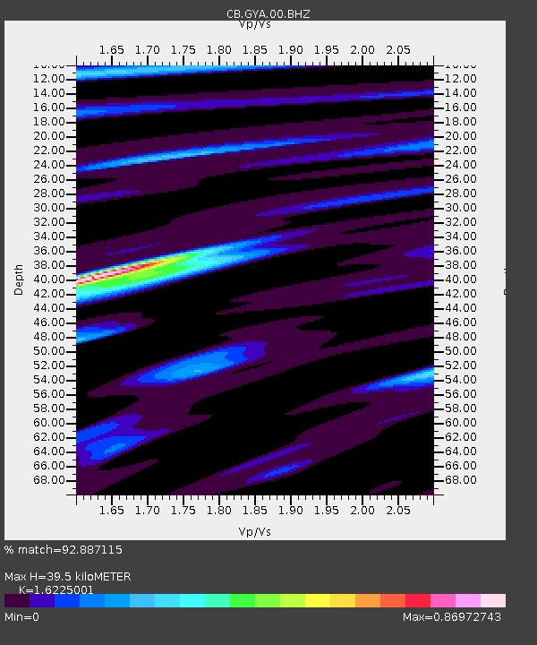
| Estimated Moho Depth: |
39.5 km |
| Estimated Crust Vp/Vs: |
1.62 |
| Assumed Crust Vp: |
6.113 km/s |
| Estimated Crust Vs: |
3.768 km/s |
| Estimated Crust Poisson's Ratio: |
0.19 |
|
| Radial Match: |
92.887115 % |
| Radial Bump: |
400 |
| Transverse Match: |
86.93121 % |
| Transverse Bump: |
400 |
| SOD ConfigId: |
11737051 |
| Insert Time: |
2019-04-26 12:37:10.938 +0000 |
| GWidth: |
2.5 |
| Max Bumps: |
400 |
| Tol: |
0.001 |
|

Signal To Noise
| Channel | StoN | STA | LTA |
| CB:GYA:00:BHZ:20170103T22:04:15.129971Z | 40.594727 | 5.104213E-6 | 1.2573587E-7 |
| CB:GYA:00:BHN:20170103T22:04:15.129971Z | 12.158097 | 9.2729346E-7 | 7.6269615E-8 |
| CB:GYA:00:BHE:20170103T22:04:15.129971Z | 12.065409 | 1.5070161E-6 | 1.2490385E-7 |
| Arrivals |
| Ps | 4.1 SECOND |
| PpPs | 16 SECOND |
| PsPs/PpSs | 21 SECOND |


