You are here: Home > Network List > CI - Caltech Regional Seismic Network Stations List
> Station BFS Mt Baldy Forest Station > Earthquake Result Viewer
BFS Mt Baldy Forest Station - Earthquake Result Viewer
| Earthquake location: |
South Of Fiji Islands |
| Earthquake latitude/longitude: |
-19.3/176.1 |
| Earthquake time(UTC): |
2017/01/03 (003) 21:52:31 GMT |
| Earthquake Depth: |
17 km |
| Earthquake Magnitude: |
6.9 Mww |
| Earthquake Catalog/Contributor: |
NEIC PDE/us |
|
| Network: |
CI Caltech Regional Seismic Network |
| Station: |
BFS Mt Baldy Forest Station |
| Lat/Lon: |
34.24 N/117.66 W |
| Elevation: |
1312 m |
|
| Distance: |
82.5 deg |
| Az: |
49.911 deg |
| Baz: |
240.7 deg |
| Ray Param: |
0.046825018 |
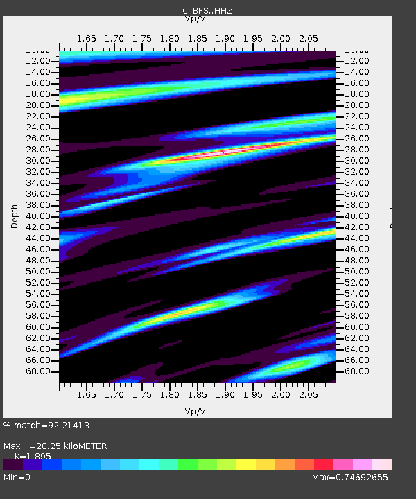
| Estimated Moho Depth: |
28.25 km |
| Estimated Crust Vp/Vs: |
1.89 |
| Assumed Crust Vp: |
6.276 km/s |
| Estimated Crust Vs: |
3.312 km/s |
| Estimated Crust Poisson's Ratio: |
0.31 |
|
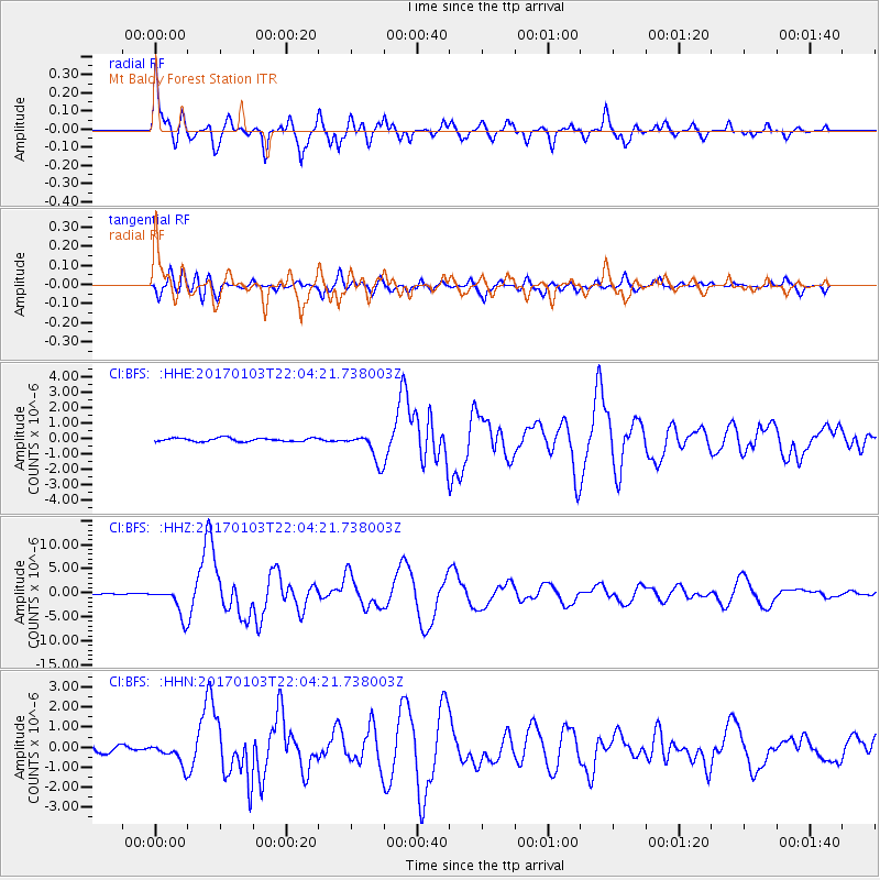
| Radial Match: |
92.21413 % |
| Radial Bump: |
400 |
| Transverse Match: |
83.499214 % |
| Transverse Bump: |
400 |
| SOD ConfigId: |
11737051 |
| Insert Time: |
2019-04-26 12:37:35.052 +0000 |
| GWidth: |
2.5 |
| Max Bumps: |
400 |
| Tol: |
0.001 |
|
Signal To Noise
| Channel | StoN | STA | LTA |
| CI:BFS: :HHZ:20170103T22:04:21.738003Z | 14.84959 | 3.1064126E-6 | 2.0919181E-7 |
| CI:BFS: :HHN:20170103T22:04:21.738003Z | 2.9051478 | 5.4177184E-7 | 1.8648684E-7 |
| CI:BFS: :HHE:20170103T22:04:21.738003Z | 7.965804 | 8.928268E-7 | 1.1208244E-7 |
| Arrivals |
| Ps | 4.1 SECOND |
| PpPs | 13 SECOND |
| PsPs/PpSs | 17 SECOND |


