You are here: Home > Network List > CI - Caltech Regional Seismic Network Stations List
> Station HEC Hector, Baker, CA, USA > Earthquake Result Viewer
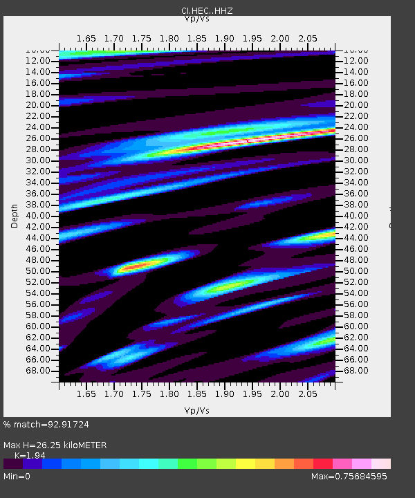
HEC Hector, Baker, CA, USA - Earthquake Result Viewer
| Earthquake location: |
South Of Fiji Islands |
| Earthquake latitude/longitude: |
-19.3/176.1 |
| Earthquake time(UTC): |
2017/01/03 (003) 21:52:31 GMT |
| Earthquake Depth: |
17 km |
| Earthquake Magnitude: |
6.9 Mww |
| Earthquake Catalog/Contributor: |
NEIC PDE/us |
|
| Network: |
CI Caltech Regional Seismic Network |
| Station: |
HEC Hector, Baker, CA, USA |
| Lat/Lon: |
34.83 N/116.33 W |
| Elevation: |
920 m |
|
| Distance: |
83.8 deg |
| Az: |
49.924 deg |
| Baz: |
241.448 deg |
| Ray Param: |
0.045952618 |
| Estimated Moho Depth: |
26.25 km |
| Estimated Crust Vp/Vs: |
1.94 |
| Assumed Crust Vp: |
6.276 km/s |
| Estimated Crust Vs: |
3.235 km/s |
| Estimated Crust Poisson's Ratio: |
0.32 |
|
| Radial Match: |
92.91724 % |
| Radial Bump: |
400 |
| Transverse Match: |
86.433174 % |
| Transverse Bump: |
400 |
| SOD ConfigId: |
11737051 |
| Insert Time: |
2019-04-26 12:37:51.130 +0000 |
| GWidth: |
2.5 |
| Max Bumps: |
400 |
| Tol: |
0.001 |
|

Signal To Noise
| Channel | StoN | STA | LTA |
| CI:HEC: :HHZ:20170103T22:04:28.128018Z | 18.686594 | 3.377747E-6 | 1.8075777E-7 |
| CI:HEC: :HHN:20170103T22:04:28.128018Z | 2.8717296 | 6.5322206E-7 | 2.2746642E-7 |
| CI:HEC: :HHE:20170103T22:04:28.128018Z | 4.883925 | 9.393622E-7 | 1.9233757E-7 |
| Arrivals |
| Ps | 4.0 SECOND |
| PpPs | 12 SECOND |
| PsPs/PpSs | 16 SECOND |


