You are here: Home > Network List > CI - Caltech Regional Seismic Network Stations List
> Station MWC Mount Wilson Obsv, Altadena, CA, USA > Earthquake Result Viewer
MWC Mount Wilson Obsv, Altadena, CA, USA - Earthquake Result Viewer
| Earthquake location: |
South Of Fiji Islands |
| Earthquake latitude/longitude: |
-19.3/176.1 |
| Earthquake time(UTC): |
2017/01/03 (003) 21:52:31 GMT |
| Earthquake Depth: |
17 km |
| Earthquake Magnitude: |
6.9 Mww |
| Earthquake Catalog/Contributor: |
NEIC PDE/us |
|
| Network: |
CI Caltech Regional Seismic Network |
| Station: |
MWC Mount Wilson Obsv, Altadena, CA, USA |
| Lat/Lon: |
34.22 N/118.06 W |
| Elevation: |
1725 m |
|
| Distance: |
82.2 deg |
| Az: |
49.76 deg |
| Baz: |
240.456 deg |
| Ray Param: |
0.0470301 |
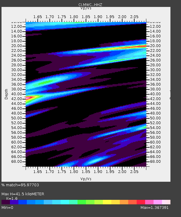
| Estimated Moho Depth: |
41.5 km |
| Estimated Crust Vp/Vs: |
1.60 |
| Assumed Crust Vp: |
6.1 km/s |
| Estimated Crust Vs: |
3.812 km/s |
| Estimated Crust Poisson's Ratio: |
0.18 |
|
| Radial Match: |
95.97703 % |
| Radial Bump: |
400 |
| Transverse Match: |
86.75122 % |
| Transverse Bump: |
400 |
| SOD ConfigId: |
11737051 |
| Insert Time: |
2019-04-26 12:38:00.465 +0000 |
| GWidth: |
2.5 |
| Max Bumps: |
400 |
| Tol: |
0.001 |
|

Signal To Noise
| Channel | StoN | STA | LTA |
| CI:MWC: :HHZ:20170103T22:04:20.198025Z | 14.294947 | 3.3489873E-6 | 2.3427769E-7 |
| CI:MWC: :HHN:20170103T22:04:20.198025Z | 2.0985973 | 9.374273E-7 | 4.4669233E-7 |
| CI:MWC: :HHE:20170103T22:04:20.198025Z | 3.0187142 | 8.638858E-7 | 2.8617677E-7 |
| Arrivals |
| Ps | 4.2 SECOND |
| PpPs | 17 SECOND |
| PsPs/PpSs | 21 SECOND |


